< CONTENT HUB >
The Best in High Tech Drone Technology and Data Intelligence.

<
Blog
>
CAA Approves StirlingX BVLOS Sandbox Airspace
Today StirlingX has secured a UK SORA-based Operational Authorisation for routine BVLOS operations in the Norfolk corridor. Combined with our earlier CAA approval for dedicated Sandbox trial airspace, which went live last month, this completes the regulatory foundation we've been working towards and clears us to commence operations.
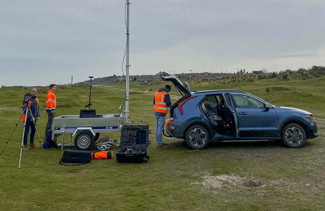
This is routine Beyond Visual Line of Sight. No Visual Observers positioned along the route, no visual mitigation of any kind. A remote pilot at our base at Felthorpe Airfield and our Sparrowhawk fixed-wing drone operating in designated airspace along 60km of the Norfolk Offshore Wind Zone cable corridor.
How we got here
StirlingX has been flying drone surveys along the NOWZ cable corridor for four years, supporting the Vattenfall and J Murphy & Sons construction project connecting 276 offshore turbines to the National Grid at Necton.
We didn't start with BVLOS. Like every operator, we began with standard VLOS approvals under PDRA01, with a remote pilot maintaining visual contact with the drone at all times. From there we progressed to BVLOS with Visual Mitigation, deploying trained Visual Observers along the route in continuous radio contact with the pilot, extending our effective range while meeting CAA requirements under a bespoke Operating Safety Case.
The BVLOS VM approach delivers results, but it carries real operational costs. Putting crew and vehicles on the ground across a long rural corridor introduces its own risks, and every repositioning of observers means additional take-offs and landings. The number of flight days required to complete a monthly survey is far higher than it needs to be, and the ground footprint is larger than it should be for what is fundamentally an aerial survey task.
The goal has always been to reach a point where a single pilot, remotely based at an airfield, can fly a full corridor survey in a fraction of the time, which is exactly what these approvals now make possible.
The CAA BVLOS Sandbox
In October 2023, StirlingX was named as one of only five UK companies selected to take part in the CAA's BVLOS Sandbox trials. The programme is designed to make BVLOS drone flights a routine reality in UK airspace, trialling how these operations can be accommodated alongside existing traffic without permanent segregation. Selection required demonstrating a credible operational use case, the technical capability to deliver it safely, and the regulatory maturity to work through a genuine airspace change process.
Our application was built around the NOWZ corridor: along, linear infrastructure project in rural Norfolk, with a defined flightpath, a known air traffic environment, and a clear commercial rationale that aligned closely with what the Sandbox was designed to test.
The Operational Authorisation
The new OA is assessed at UK SORA SAIL 2 and is valid until June 2027, reflecting a safety case built around the UK SORA methodology and accepted by the CAA as robust and scalable. It authorises untethered BVLOS flights within defined operational volumes up to 400ft AGL in both Class D and Class G airspace, approved up to Ground Risk Class 6 with specified mitigations including sheltering and ground observation.
The assessment reflects CAA confidence in our ability to manage both air and ground risk in a relatively complex operational environment. It also places us within the framework the CAA set out in CAP 3038and CAP 3182 on the path to routine BVLOS by 2027, moving us from trial and demonstration activity into repeatable, routine operations in segregated airspace.
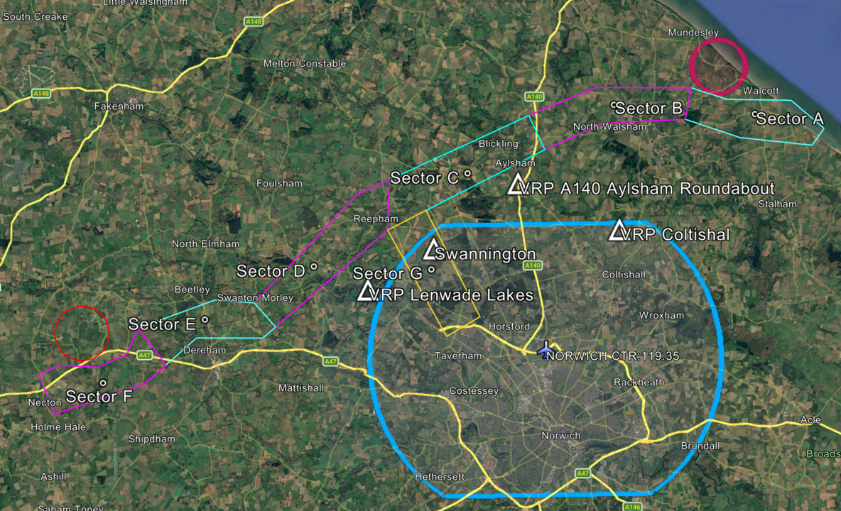
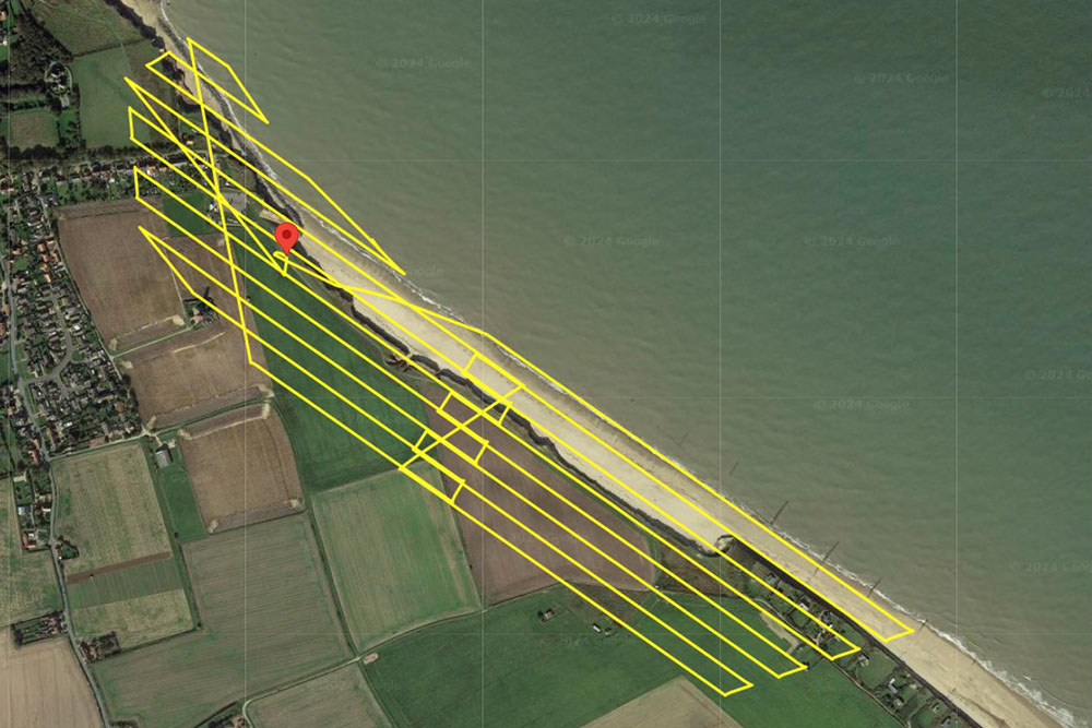
The approved airspace
The Temporary Reserved Area broadly follows the NOWZ cable corridor from its landfall near Happisburgh on the Norfolk coast, west to the substation at Necton. A link corridor extends south from Cawston to Felthorpe Airfield, where our remote pilots will be based. The TDA has a vertical ceiling of 750ft on the Norwich QNH, equivalent to approximately 500ft AGL along the route, with all survey flights operating between 300ft and 400ft AGL.
The TDA is divided into three independently activatable sections: west, centre and east. Each activation is announced by NOTAM, and during activation only transponder-equipped aircraft may operate within the TDA. Norwich ATC is the Air Navigation Service Provider for the trial, managing the TDA and providing a flight information service to our remote pilots, a relationship developed over months of coordination and planning that is central to the safety architecture of the whole operation.
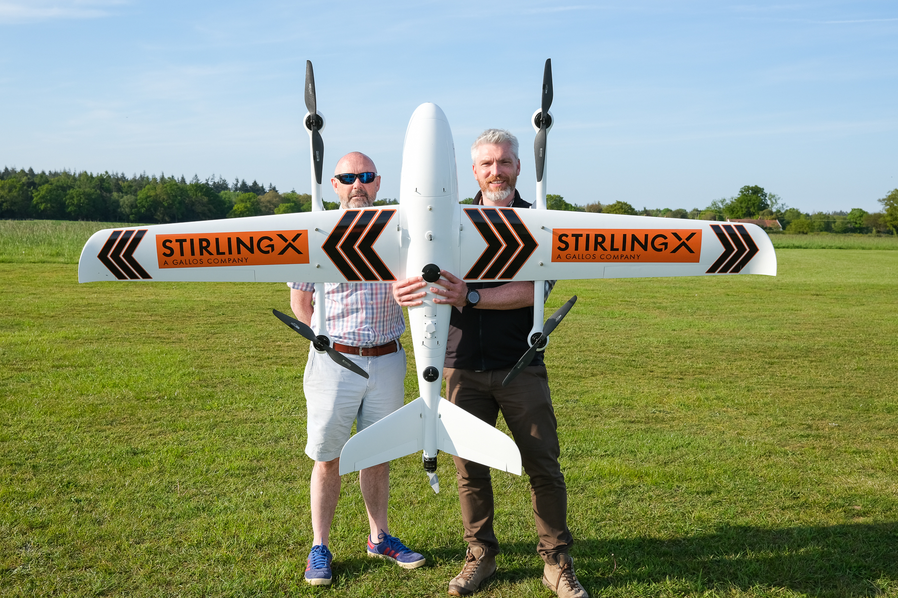
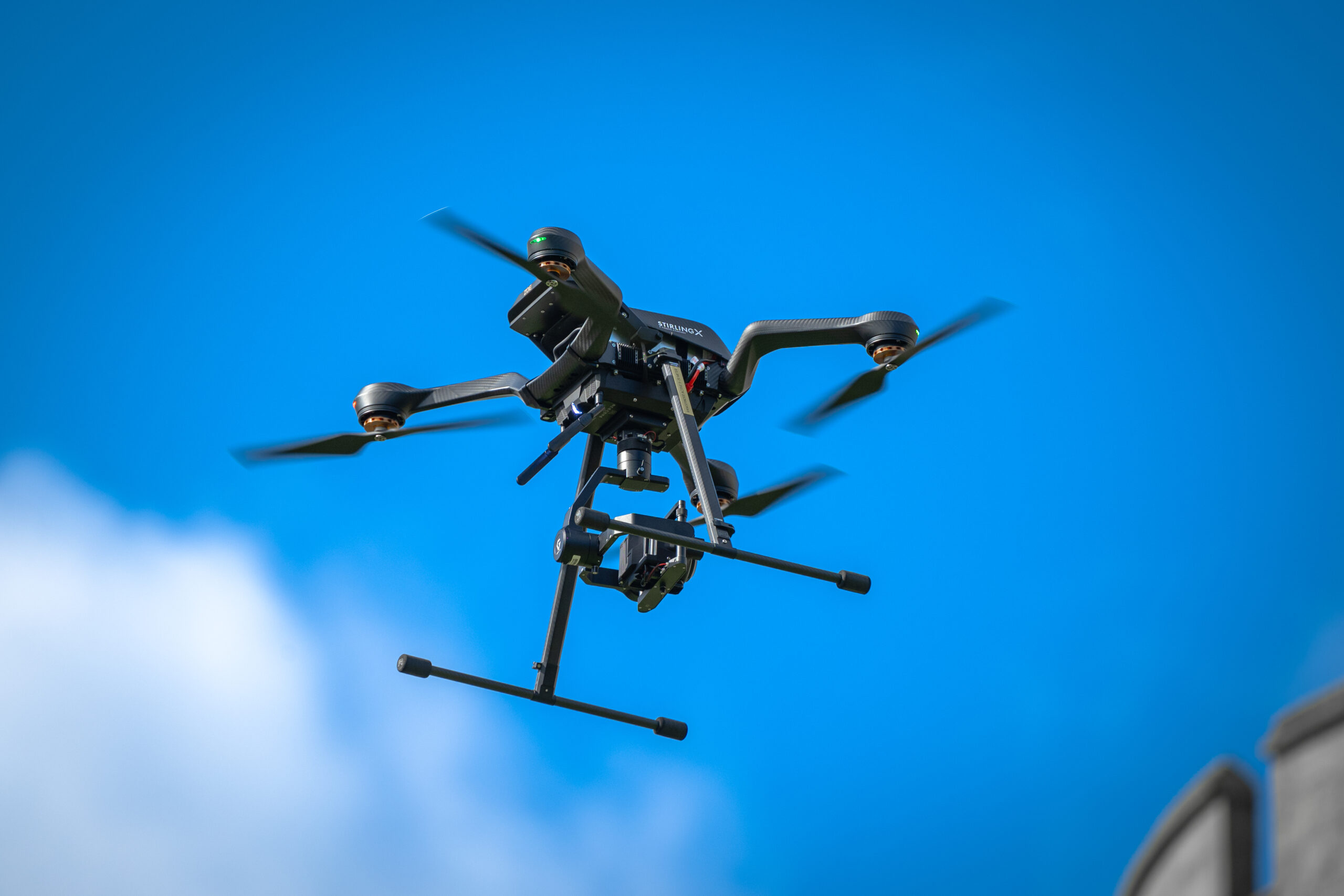
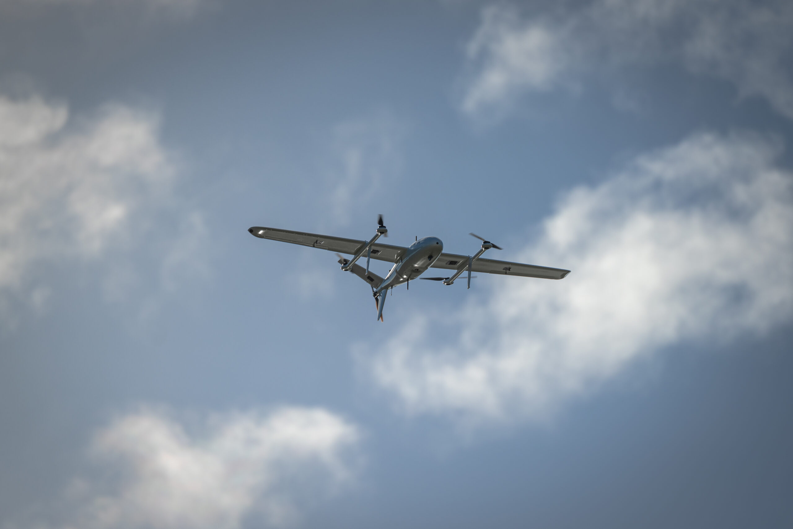
The aircraft
Our Sparrowhawk is a fixed-wing VTOL drone built for exactly this kind of operation. It carries ADS-B transmit and receive, a Mode S transponder, redundant 4G/5G command and control links, high-intensity strobe lighting and around two hours of endurance at a cruise speed of up to 50 knots. It's electronically visible to EC ground stations along the route via PilotAware ATOM stations, and to any other aircraft with an ADS-B receiver, which is a fundamental requirement for operating without visual observers on the ground.
The sensor payload covers the core survey requirements: LiDAR for terrain and asset modelling, photogrammetry for construction progress and environmental monitoring, and video for real-time situational awareness and review.
What comes next
With the Operational Authorisation now in place and the Temporary Danger Area EGD297 established, the next phase is about proving that routine BVLOS corridor operations can be flown safely and repeatably within a managed TDA/TMZ environment. Over the coming months we will focus on flying regular missions along the Norfolk corridor, collecting data on safety performance, system reliability and airspace interactions under the specific conditions set out in our UK SORA‑based OA.
There is no predefined roadmap for this corridor that removes either the TDA or the TMZ, and we are not assuming one. Instead, our emphasis is on demonstrating what can be achieved today: a single remote pilot at Felthorpe, a fixed‑wing BVLOS platform, a defined operational volume and a collaborative surveillance environment where electronically conspicuous traffic is known to Norwich ATC and to our ground systems.
The approvals we now hold give us more than a one‑off trial; they provide a pattern we can reuse where a TDA is the appropriate tool. The combination of a UK SORA SAIL 2safety case, defined flight and contingency volumes with an associated ground risk buffer, and ANSP‑managed services within a TDA/TMZ structure creates a deployable model for other long linear infrastructure projects. As we build operational hours in EGD297, we will share lessons with the CAA, Norwich ATC and other stakeholders to inform future policy on how BVLOS accommodation in TDA airspace can support the wider Future of Flight programme.
Why this matters
Routine BVLOS over long linear infrastructure isn't a niche capability. Power lines, pipelines, rail corridors, cable routes: these are the assets that need the most frequent inspection and monitoring, and they're exactly the ones that VLOS operations struggle to cover efficiently .The UK's Future of Flight framework explicitly targets infrastructure inspection as a priority BVLOS use case by 2027, and holding a live OA in a CAA Sandbox corridor positions StirlingX as a credible delivery partner for those programmes.
The model we're building in Norfolk, a remote pilot, a fixed-wing drone, designated trial airspace and integrated ATC coordination, is the template for how this kind of work gets done at scale. We'll be sharing progress as operations develop.
Full details of the trial, the proposed TDA and the consultation process are on our website: https://www.stirlingx.io/legals/bvlos-sandbox-trial
<
Blog
>
Energy Whitepaper: Reduce Operational Risk with Real-Time Infrastructure Insight
Energy operators are under sustained pressure to deliver safe, reliable, and cost effective operations while navigating ageing infrastructure, workforce constraints, regulatory scrutiny, and increasing exposure to environmental and security risks. Decisions are often made with incomplete, delayed, or fragmented data.
StirlingX provides a data intelligence approach that integrates aerial data capture, secure data pipelines, and operational analytics into a single decision environment. Rather than focusing on drones as an end product, StirlingX focuses on how high fidelity site data can be collected, governed, analysed, and turned into practical operational insight.
This paper outlines how StirlingX’s approach supports energy operators across risk reduction, cost control, and operational outcomes without disrupting existing systems or processes.
Read the whitepaper here.
<
Blog
>
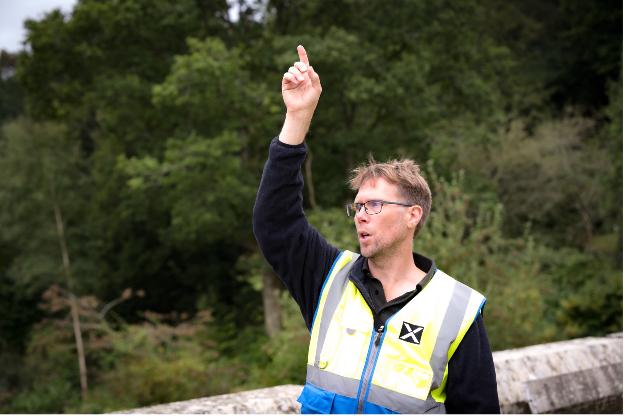
Meet The Team: Matt Rake, Chief Regulatory Officer
From flying air ambulance missions over Saudi Arabia to navigating the corridors of European Union national aviation authorities, Matt Rake has spent over two decades operating at the sharp end of aviation — first in the cockpit, and now in the regulatory arena. As StirlingX's Chief Regulatory Officer, Matt is the person responsible for making sure we can do what we want to do, and for quietly shaping the rules that will define the entire drone industry for years to come.
We sat down with Matt to talk helicopters, the Hajj, Amazon, and why patience might be the most important skill in the business.
From Piston Engines to Turbines: Building a Career in the Air
Q: You describe yourself as a career helicopter pilot. Where did it all start?
Matt: I'm not ex-military, so it was all self-funded — from my private pilot licence all the way through to commercial. I did a chunk of my training in the UK and then went to Florida to build hours and experience. I ended up getting a job as a flight instructor out there, teaching pilots to fly in normal (visual) conditions and under instrument conditions — simulated instrument meteorological conditions (IMC), which is a different and more complex skillset entirely. Two years of that gave me a really solid grounding in everything from meteorology to aircraft systems.
Q: What came after Florida?
Matt: I came back to the UK and carried on instructing — primarily in Northern Ireland and England — and then got a bit restless one summer and went and flew photographers along the south coast of France. Saint Tropez. Low-level, below 200 feet, chasing yachts while a photographer on board took pictures of people on their boats. Someone had rigged up a scrolling phone number and website on the side of the helicopter so people could buy the photos online. It was brilliant fun. Nice weather, nice apartment. I did a season of that and then it was back to reality.
Q: Your career then took a pretty dramatic turn with a role in Saudi Arabia. What was that?
Matt: That was my first job flying larger twin turbine aircraft under the two crew concept. I went to work for Abu Dhabi Aviation — they'd won a contract to deliver the first civilian air ambulance service in Saudi Arabia, operating for the Saudi Red Crescent. We flew Bell 412s — the Huey, and we were doing emergency medical services out of Riyadh, Jeddah and Mecca. Dealing with casualties for road traffic accidents, mostly. Saudi has one of the worst records in the world for those.
Supporting the Hajj was very interesting, this is the religious festival near Mecca. Because myself and most of the crews were not Muslim, we weren't allowed within 25 kilometres of the city, so they based us out in the desert. If there was a requirement for us to collect casualties, usually a crush or stampede — hundreds of people could get injured in those — we'd fly in, load up and evacuate to the hospital. No lingering. It was intense flying, hours of waiting interspersed with high octane bursts of activity. Additionally, because you're operating heavy aircraft at high altitude in extreme heat the air is thin, the aircraft is struggling for power, and you're constantly managing fuel and endurance. You learn a lot very fast.
Q: From the desert to the North Sea — that's quite a shift.
Matt: I spent five winters in the North Sea flying Sikorsky S92s. Completely different world — again two-crew operations, but this time in real instrument meteorological conditions most of the year, landing on floating rigs and support vessels in some lively weather. It's a fantastic bit of kit, the S92. The President's getting a new fleet of them for Marine One soon enough. Anyway, I did five years of that until the oil price dropped and they started offering voluntary redundancy. I put my hand up. Took the money and started a company.
Entrepreneurship and the Move into Drones
Q: You went from the North Sea to running your own business. How did that happen?
Matt: I bought a Robinson R22 — a small single-engine piston helicopter — and set up a training company at Doncaster Sheffield Airport with my partner, Helen. I called it Hummingbird Helicopters. The region had almost no helicopter training provision, so I got busy quickly, grew the fleet to four helicopters, brought in a team of instructors, and went from delivering private pilot licence training to commercial pilot and flight instructor courses. It was seven days a week, tense and tiring, but great fun.
Q: And that's where drones came in?
Matt: I'd heard that drone pilot training was starting to be formalised, so I went up to Newcastle and did a course myself — just to understand it. I realised almost immediately that it was all based on crewed aviation training principles, which was exactly what we'd been doing for years. So, I wrote an exposition, submitted it to the CAA, explained why we were qualified to do it, and they came and audited us and said yes. We became a National Qualified Entity — an NQE — which meant we could train and assess drone pilots on behalf of the CAA. We rebranded to Hummingbird Helicopters and Drones and spun up a separate UAV entity.
Q: Then Amazon got in touch?
Matt: Out of nowhere, really. I think it started with a LinkedIn message. By that point I'd done about five years running the company and I was ready for something different, so when they said "come and run our UK flight ops team," I said yes. We sold the company and I began working from Cambridge for Amazon Prime Air. The whole Amazon Air Prime concept is packages delivered by drone within 30 minutes or less.
Amazon, and the Regulatory Frontline
Q: What did your time at Amazon teach you about regulations?
Matt: Everything — and what not to do. Amazon's approach with regulators was essentially to go in loudly, make demands, and threaten to leave if they didn't get what they wanted. In my view, that is entirely the wrong approach. It might occasionally work in the short term, but it destroys relationships, good will and the trust that you need for the long game. I watched it happen, and it shaped my whole philosophy in the opposite direction.
I also learned a huge amount about how to identify the right regulatory environments. When I went back to Amazon for a second stint, my job was to find the best jurisdiction in the EU for their European operations. I met with the aviation authorities in Spain, Italy, Poland, Germany, France — sitting across the table, understanding what they could and couldn't move on, and finding the right fit. We narrowed it down to Italy and the UK. In the UK, we down-selected Teesside Airport as the site — partly because of a nearby Amazon Robotics warehouse, partly because of the genuinely progressive local leadership there who would help push things along.
Q: What does your role as Chief Regulatory Officer actually involve day to day?
Matt: There are really two sides to it. The first is compliance — making sure we have the approvals we need to operate commercially in the way we want to operate. The second, and arguably more important piece, is engagement. We're operating at the very edge of what the current regulations allow. We're pushing for BVLOS — Beyond Visual Line of
Sight operations — and for multiple simultaneous operations (MSO), where one pilot can manage several drones across different locations at once. Those regulations don't fully exist yet. So, part of my job is to help the CAA understand the technology, trust the technology, and help them shape the regulations accordingly.
Q: How do you approach that without pushing too hard?
Matt: Crawl, walk, run. That's it. You approach regulators gently, build trust incrementally, and only ask for more once you've demonstrated that you can handle what you already have. You also have to genuinely understand what they care about — and the CAA care about one thing: safety. Not commerce. Safety. Once you accept that, you stop fighting it and start working with it. You prove that your technology is safe, your procedures are robust, your emergency protocols are solid. Then they'll walk with you.
Q: What do organisations most commonly get wrong with regulators?
Matt: They go in too fast and too loud. They don't put enough thought into their safety case, and they don't put themselves in the shoes of the regulator. The CAA is not your adversary — they have a job to do. When you treat them as a partner and earn their trust, they become enormously helpful. When you treat them as an obstacle, they become exactly that.
Q: Why does all of this matter commercially?
Matt: Because we're a business. Simple as that. BVLOS and multiple simultaneous operations are the two things that will genuinely transform the economics of this sector. Right now, you need a pilot standing in a field watching every drone they fly. Remove that constraint, and you remove a huge operational cost. You can scale. You can pass savings on to customers. The sky isn't going to go dark with drones until those two things are in place — but when they are, this industry changes fundamentally.
Q: How confident are you that those regulations are coming?
Matt: Very. The UK has committed to introducing a path for Operators to conduct routine BVLOS regulations in 2027. The Americans are working on Part 108. Australia is moving fast. The EU is gradually formalising it. China is already there with routine BVLOS permissions, but western countries aren’t far behind, and we at StirlingX will be ready when it happens. StirlingX is one of only six companies in the UK authorised to conduct BVLOS operations under the CAA's sandbox trial. With regard to BVLOS, we’ve crawled and walked and will be running in May this year.
Q: What drew you into regulations specifically, rather than staying operational?
Matt: Honestly? It was organic. I never planned it. But 20-plus years of operational experience gives you a fluency with regulations that many people in this industry don't have. Amazon brought me in partly because they didn't understand the regulatory
landscape and needed someone who did. And once you're in those rooms, having those conversations, you realise the enormous leverage you can have — not just for your own company, but for the industry as a whole. I find that genuinely exciting.
Quick Hits with Matt
Lives: Sheffield.
Joined StirlingX: February 2024.
Proudest regulatory achievement: Navigating the CAA's six-stage Airspace Change Process to secure airspace for BVLOS operations.
<
News
>
StirlingX Seed Funding Announcement
Cambridge, United Kingdom, 27 November 2025 - StirlingX, the UK-based drone operations and data intelligence company, has closed its extended Seed round at a total of $11 million. The SAFE investment, which builds on the initial seed funding secured over the summer, was led by the RCM Private Markets Fund managed by Rokos Capital Management, with participation from new and existing global investors including GALLOS Technologies, ONE9, and a distinguished group of angel investors.
This milestone places StirlingX among the top 5% of European technology start-ups by total seed capital raised and reinforces the company’s trajectory as a leader in secure drone and data systems for allied nations and critical national infrastructure.
The extended funding will accelerate ongoing product development, support international market growth, and expand recruitment across engineering, AI, and data science. It also enables StirlingX to scale its manufacturing and R&D operations at its Cambridge and Oxford sites to meet growing government and commercial demand.
StirlingX is actively delivering on live critical national infrastructure projects, supporting clients such as Murphy and National Grid across pre-construction planning, construction-phase operations, surveying, and compliance.
Dean Jones, CEO of StirlingX, said:
“Completing our seed round marks another significant step in StirlingX’s growth. The confidence shown by our investors allows us to push further and faster in delivering sovereign, secure technology to partners across critical infrastructure and defence. With strong momentum behind us, we are well positioned to scale and deepen our impact across the markets we serve.”
Sir Jeremy Fleming, Chairman of StirlingX, commented:
“This is another clear signal of StirlingX’s ambition and progress. With world-class technology and a rapidly growing customer base, the company is demonstrating the essential role British innovation can play in securing and enhancing allied capability across critical national infrastructure and defence sectors.”

<
News
>
Second Front Systems and StirlingX partner to support UK Government with secure, sovereign drone deployments
London, UK [13/01/2026] — Second Front Systems (2F), a leader in accelerating the adoption of commercial technology for defence, today announced its partnership with StirlingX, the UK-based drone operations and data intelligence company. Together, the organisations will enable the Ministry of Defence (MOD), the national security community, and Critical National Infrastructure (CNI) operators to rapidly adopt sovereign, high-assurance drone capabilities through a secure software deployment pathway.
The partnership provides StirlingX with a significantly accelerated and compliant route into sensitive government and enterprise environments. By leveraging 2F Game Warden, StirlingX can deliver its mission-critical drone software directly into restricted and high-security ecosystems - without the lengthy accreditation cycles traditionally required. This ensures operators receive secure, sovereign capabilities at the speed operational conditions demand.
“This partnership is a step-change for how trusted drone technology is delivered into the UK defence ecosystem,”
said Dean Jones, CEO of StirlingX.
“By integrating our sovereign drone and data intelligence software into Second Front Systems’ secure deployment pathway, we’re removing one of the biggest barriers to adoption in high-assurance environments. It means MOD, national security partners, and Critical National Infrastructure operators can access advanced, mission-ready capabilities faster - strengthening UK resilience, protecting sensitive operations, and ensuring critical technology remains under national control.”
The partnership will integrate StirlingX’s flight-control, data-processing, and operational-management software into Game Warden's secure landing-zone environment. This provides a unified solution suitable for highly sensitive operational contexts including MOD programmes, national security use cases, and CNI operations. The integration ensures that StirlingX’s software is protected from cyber threats, updated seamlessly, and deployed in full compliance with stringent UK security requirements - a critical need at a time when recent cyber incidents have disrupted operations across major UK manufacturers.
“Accelerating the delivery of trusted technology to mission users is exactly what Game Warden is built for,”
said Enrique Oti, CSO at Second Front Systems.
“StirlingX is developing some of the most capable, mission-flexible autonomous aerial systems in the UK to generate critical mission data. This partnership ensures their sovereign capabilities can be quickly and efficiently deployed into secure environments – whether supporting MOD missions, safeguarding critical national infrastructure, or enabling high-assurance operations for organisations with elevated security needs.”
Second Front Systems and StirlingX will begin coordinated go-to-market activity immediately, with early deployments expected to commence later this year.
About Second Front Systems
Second Front Systems Limited (2F) is the UK arm of Second Front Systems, a defence technology company founded to accelerate the secure delivery of software to allied nations worldwide. 2F provides proven, integrated solutions that enable the rapid deployment of mission-critical commercial software—from mission planning and training systems to cybersecurity tools, productivity software, and secure large-language models.
Assured by the UK Ministry of Defence and NATO, 2F strengthens digital sovereignty and allied interoperability by reducing the need for reapproval, compliance review, or technical rework, ensuring secure software reaches the mission faster. Learn more at secondfront.co.uk.
About StirlingX
StirlingX is a UK technology company specialising in advanced drone operations and data intelligence for complex and high-security environments, including Critical National Infrastructure and defence.
By integrating automated drone platforms, resilient communications, and AI-driven analytics, StirlingX turns aerial and sensor data into actionable intelligence; accelerating decision-making, improving efficiency, and reducing operational risk.

<
News
>
StirlingX appoints former GCHQ Director Sir Jeremy Fleming as Chairman
StirlingX, the UK-based drone and data intelligence company, has appointed Sir Jeremy Fleming KCMG CB, former Director of UK intelligence, cyber and security agency GCHQ, as its Chairman. Sir Jeremy’s appointment marks a significant milestone in StirlingX’s mission to deliver secure, advanced drone and data analytics technologies for defence, critical infrastructure, and commercial applications. Through his leadership in national security and cyber strategy, he will guide the company as it scales secure, UK-manufactured technology for domestic and allied markets.
The appointment comes at a time when the role of drones and autonomous systems is being transformed in defence and security for both nations and corporates. The ability to deploy AI-powered coordinated drones cost-effectively, and gather and process the data from them, is critical to advantage on the battlefield, and central to security and efficiency for civilian operations.
Founded by veterans of UK specialist military units and intelligence agencies, StirlingX designs and manufactures its drones, autonomous systems and data analytics technologies in Britain, ensuring security, resilience, and independence from adversary-sourced components. Its technologies are engineered to operate in the most demanding environments, where trust, reliability, and performance are mission critical.
The use cases for StirlingX’s technology include:
Defence
StirlingX is advancing technologies in the field of autonomous robotics and data analytics that help the military see, understand, and act faster on the battlefield. Their systems use these capabilities to collect information, detect threats, and counter hostile drones. In practice, this means building tools that improve how armed forces gather intelligence, defend against electronic threats, and stay a step ahead in complex environments. The StirlingX technologies enable:
- Intelligence, Surveillance, and Reconnaissance (ISR)
- Electromagnetic Warfare (EW)
- Counter-UAS
StirlingX, which is actively engaged in tendering with the UK’s Ministry of Defence (MoD), is focused on supporting the UK’s 5-EYES partners while engaging with NATO and democratic allies worldwide. Its systems, validated in contested and complex environments, are designed to meet the evolving demands of modern defence operations.
Dual-Use in Critical National Infrastructure (CNI)
Alongside its defence work, StirlingX applies the same resilience and innovation to critical national infrastructure (CNI) and commercial markets. From surveying offshore wind farms to monitoring transport corridors and securing energy assets, StirlingX provides organisations with end-to-end intelligence solutions that reduce cost, complexity, and risk.
Sir Jeremy Fleming, Chairman of StirlingX, said:
“Drones deployed autonomously and at scale are going to change all our lives. They’ll help keep us safe, give us real-time intelligence pictures, and transform the battlefield. StirlingX is at the forefront of that revolution, providing sovereign capability that delivers vital real-time data, powered by AI to identify emerging threats and generate critical advantages over adversaries. I look forward to working with the excellent StirlingX team to further accelerate their impressive progress and prospects.”
Dean Jones, CEO of StirlingX, said:
“Having Sir Jeremy as our Chairman underlines the importance of what we are building. StirlingX was founded on the principles of precision, trust, and resilience learned in the UK’s most demanding operational environments. Today, those same principles drive our mission to provide secure intelligence solutions for our defence partners and critical infrastructure operators.”
<
Blog
>
Meet The Team: Rowley Cory-Wright, Head of Flight Operations
From commanding 100-ton tanks in the desert to piloting helicopters over the North Sea, Rowley Cory-Wright brings a wealth of high-stakes operational experience to StirlingX. As our Head of Flight Operations, Rowley is responsible for bridging the gap between cutting-edge drone technology and the practical, safe execution of complex data-gathering missions.
We sat down with Rowley to discuss his journey from the Royal Dragoon Guards to the cockpit, and how his "planning-first" philosophy is shaping the future of drone swarms and Beyond Visual Line of Sight (BVLOS) operations.
From Heavy Cavalry to High-Altitude Surveillance
Q: Your career started in a very different kind of vehicle - the Challenger 2 Main Battle Tank. What was that experience like?
Rowley: I was commissioned into the Royal Dragoon Guards as a troop leader, commanding three Challenger 2 tanks. It was an incredible learning curve. By the time we were operating in Basra, those tanks weighed nearly 100 tonnes. My role involved managing a four-person crew - driver, gunner, loader, and radio operator - while coordinating with a troop sergeant and corporal.
Q: You also spent time in Land Rovers doing "force protection." How did that prepare you for logistics and operations?
Rowley: That was during Operation TELIC. We were responsible for protecting convoys carrying essential supplies like food and water from the Kuwaiti border. It taught me everything about identifying "vulnerable points" - places like road junctions where things slow down and risks increase. It was all about keeping the move fluid and safe, which is exactly what we do in flight ops today.
Q: What prompted the move from tanks to the cockpit?
Rowley: I simply wanted to fly! After training, I joined the Army Air Corps, eventually becoming the second in command of a manned airborne surveillance Rotary Wing Squadron in Northern Ireland. I supported counter-terrorism operations nationwide, flying in very demanding environments.
The Transition to Civilian Aviation and Drones
Q: You have over 3,000 flying hours. How did that lead you to the drone industry?
Rowley: After the military, I flew transport helicopters (specifically the AW139) to gas rigs out of Norwich. While I loved flying, civilian transport can be repetitive - you’re often just flying from A to B. I wanted something more tech-focused and fast-paced.
I joined Hexcam in 2016, took over operations in 2017, and eventually ran the company until we merged with StirlingX in 2025. Drones allow me to stay in the aviation world while solving brand-new problems every day.
Operations at StirlingX
Q: What does "Operations" actually look like at StirlingX on a day-to-day basis?
Rowley: It’s about getting out there and gathering data on Critical National Infrastructure (CNI) assets effectively and safely. We might be on a wind farm one day and in the middle of London or Sheffield the next. Great operations are often invisible to the customer - if we’ve flown safely and efficiently without them even knowing we were there, we’ve done our job.
Q: What is the biggest operational challenge you are tackling this year?
Rowley: BVLOS (Beyond Visual Line of Sight). The regulations are finally at a point where we can trial these operations safely. We are using our work in Norfolk as a "cookie-cutter" model to scale these lessons to sites in Wales, Scotland, and beyond.
Q: What’s your philosophy when it comes to scaling operations?
Rowley: Safety comes first - always.
You need the right supervision, the right people and the right processes before you scale. Efficiency matters, but never at the expense of safety. The aim is to build systems that allow scale without increasing risk.
Q: What is your "dream" setup for the future of flight ops?
Rowley: A 1-to-many swarm formation. In this model, an aircraft captain in a control room monitors the mission while a co-pilot and ground handler manage multiple drones on-site. Instead of one drone flying a corridor five times, a swarm flies it once. This massively increases flight efficiency and reduces what I call "link time" - the downtime spent moving people and setting up equipment.
Q: What is the most important lesson you’ve carried over from your military career?
Rowley: Planning. I learned the hard way that not enough planning leads to inefficiency. In the drone world, you can spend 20 minutes flying but two hours setting up and moving. My goal is to minimize that "link time" through meticulous prep.
Q: What do you look for when building a high-performing team?
Rowley: I look for people who can think outside the box and bring enthusiasm, but I want a measured approach. I don’t want "gung-ho" operators; I want people who think deeply before throwing a drone into the air.
Quick Hits with Rowley
- Lives: Norwich.
- Family: Married with two kids.
- Volunteer Work: Instructor for the Duke of Edinburgh Award.
<
Blog
>
From Obligation to Opportunity: The Power of Regulation
In many organisations, compliance is treated as a necessary burden. At StirlingX, we view it as a launchpad for performance, resilience, and trust.
Regulatory alignment isn’t a box ticking exercise; it is a strategic capability that differentiates how we plan, operate, and deliver outcomes for our customers, particularly across Critical National Infrastructure.
A clear example are our BVLOS VM permissions, which enable us to operate further, faster, and safer. These approvals compress inspection windows from weeks to hours, accelerating decision cycles while enhancing safety margins. That is more than operational efficiency; it is measurable value creation for clients who need reliable, timely insights without compromising safety.
Our approach goes beyond permissions. We engage proactively with the CAA, our participation in the BVLOS Sandbox is a tangible illustration, so that our operational models are shaped by, and aligned with, the latest regulatory thinking. This is reinforced by ISO aligned management systems (9001 for quality, 14001 for environmental management, and 45001 for occupational health and safety), giving customers confidence that we deliver consistently, responsibly, and at pace. Together, these elements allow us to operate where others cannot and to do so with a level of assurance that stands up to scrutiny.
By embedding compliance into our operating DNA, we:
- Secure faster approvals for complex and novel operations through robust safety cases and audit ready documentation.
- Reduce risk for clients and stakeholders by designing safety, environmental stewardship, and worker protection into every workflow.
- Unlock access to high value, regulated markets where credibility, reliability, and repeatability are non-negotiable.
- Build trust through transparency, evidence based reporting, and continuous improvement.
Regulation is not a necessary burden; it is enabling us to lead. At StirlingX, we see disciplined compliance as the engine of innovation, speed, and client assurance.
If you’d like to explore how this approach can support your infrastructure operations, we’re always happy to talk. Contact us today.
<
Blog
>
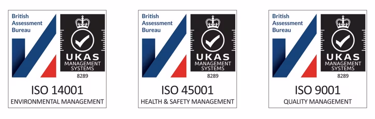
Leading the Way with ISO Excellence
These internationally recognised standards reflect our commitment to excellence across every aspect of our operations, from customer satisfaction and environmental stewardship to the health and safety of our teams.
Our decision to pursue ISO certification was driven by a desire to formalise the high standards we already uphold and to benchmark ourselves against the best in the industry. As one of the few drone operators in the UK to hold all three certifications, we are setting a new precedent for professionalism and accountability in the uncrewed aviation sector.
The journey to certification was rigorous. It required the development and implementation of a comprehensive Management System, covering all locations, staff, services, and internal processes. We adopted a lifecycle perspective to understand our environmental impacts, enhanced our emergency preparedness, and strengthened contractor oversight. Internal and external audits, led by qualified auditors and a UKAS-accredited Certification Body validated our compliance and continual improvement efforts.
ISO certification helps us consistently meet customer expectations, reduce operational risks, and improve performance across the board. It also reinforces our reputation as a trusted partner in complex and sensitive environments, including in higher risk, urban thermal mapping and cable corridor surveys.
In just 18 months, StirlingX has achieved remarkable milestones. We acquired a professional drone services company, expanding our capabilities and expertise. We established two new operational sites, Pathfinder in Buckinghamshire and Watchtower in Cambridgeshire, to support growing demand. And now, with triple ISO certification, we’ve laid a robust foundation for sustainable growth and innovation.
As we look ahead, we remain committed to pushing boundaries, embracing technology, and delivering safe, reliable, and unobtrusive aerial imaging and data collection. StirlingX is not just keeping pace, we’re leading the way.
“Achieving ISO 9001, 14001 and 45001 certification is a landmark moment for StirlingX. It reflects the discipline, care and innovation that underpin everything we do, from how we manage risk and deliver quality, to how we protect our people and the planet. These certifications aren’t just badges; they’re proof that our systems, our culture and our commitment to excellence are built to last. I’m incredibly proud of the team and what we’ve accomplished together.”
Dean Jones CEO, Stirling
<
Case Study
>
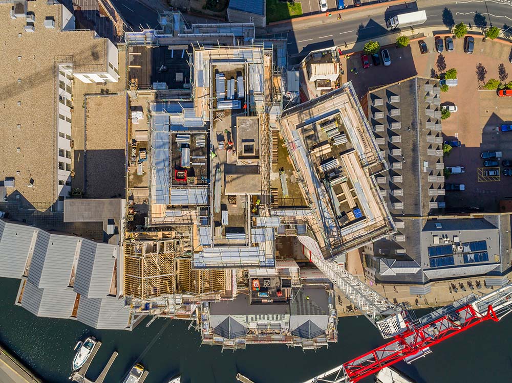
The Winerack, Ipswich – Construction Monitoring, RG Carter
The Problem
The project required clear, high-quality progress imagery for both internal and external communications, taken from multiple angles, while working within a confined city-centre site next to a busy quayside.
The Solution
- Conducted regular aerial surveys using DJI Inspire 2 with X5S camera in dual-operator mode for cinematic 4K footage.
- Captured high-resolution stills and video from multiple perspectives to illustrate progress
- Used DJI Phantom 4 Pro for interior shots in GPS-limited areas such as the car stacker system.
- Coordinated permissions and RAMS with ABP Port of Ipswich to ensure safe, compliant operations.

Outcomes
- Provided RG Carter with professional aerial visuals for progress reporting and stakeholder communications.
- Delivered content for internal updates and a final project video case study.
- Completed all work without disruption to site operations or local surroundings.
<
Case Study
>
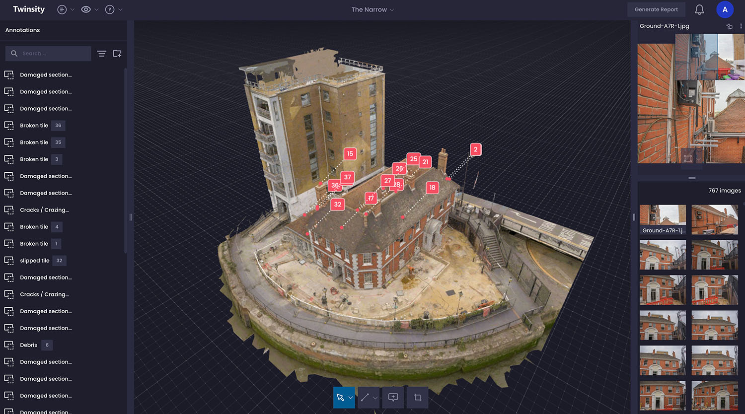
3D Digital Twin – Roof Inspection of ‘The Narrow’, Thompsons (Sigma Group)
The Problem
Gordon Ramsay’s ‘The Narrow’ restaurant sits adjacent to the River Thames and beneath tall neighbouring apartments, making roof access challenging and risky. Surveyors needed a way to safely inspect roof conditions and plan scaffolding or MEWP access without repeated physical visits.
The Solution
- Combined aerial drone imagery with ground laser scan (TLS) data to create a highly accurate 3D Digital Twin.
- Used the Twinspect platform to allow surveyors to navigate the model, annotate points of interest, and link directly to original high-resolution images.
- Coordinated closely with residents and maintained visual observation for safe drone operation in a constrained environment.
- Enabled distance and area measurements for planning and quantity take-offs.
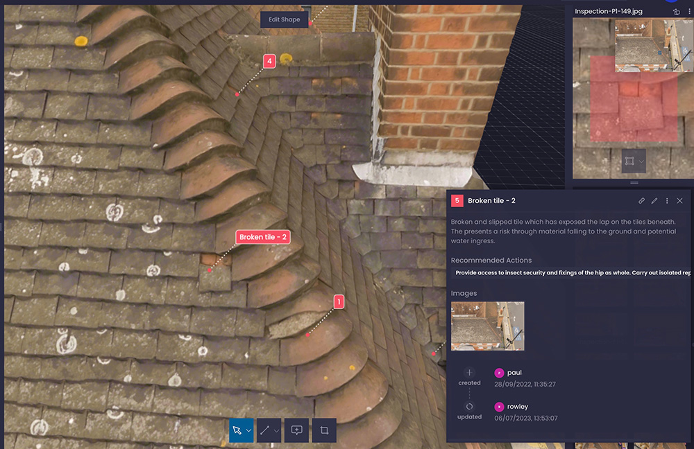
Outcomes
- Surveyors could carry out detailed desktop inspections safely and efficiently.
- Annotations were geo-referenced,eliminating duplicate reporting errors.
- Facilitated focused physical access and preparation for refurbishment works.
- Generated PDF condition reports and shared digital models with multiple teams while maintaining controlled access.
<
Case Study
>
3 km Coastline Intertidal Survey Framework Contract, Cefas
The Problem
Capturing the full intertidal zone requires surveys during spring tides, within a tight 2-hour window around low tide. Traditional ground surveys struggle to cover 3km in this timeframe, leading to inconsistent data. Drones solve this, but range limitations mean enhanced permissions and careful planning are essential.
The Solution
StirlingX combines advanced CAA permissions, innovative planning, and the latest drone tech to deliver accurate, secure data capture under strict time constraints. Dual-pilot workflows and rapid mobilisation allow us to exploit short capture windows, even at dawn or dusk. We partner with PDC Engineering for independent Ground Control Points (GCPs) and use temporary, eco-friendly markers to protect the environment. Our Operational Authorisations enable Beyond Visual Line of Sight (BVLOS) with visual mitigation, flying DJI M300 drones up to 9 km from the Remote Pilot—boosting efficiency for large and linear sites.

Outcomes
Using the DJI M300 with a P1sensor, we deliver 1.5 cm GSD imagery to Cefas reliably within tidal windows. Initialcrews of three have already reduced to two without compromising safety orquality—thanks to our extended flight permissions and optimised processes.
<
Case Study
>
Happisburgh Intertidal, Beach & Cliff Erosion Monitoring, Vattenfall
The Problem
The Happisburgh coastline is highly dynamic, with beach levels and cliff profiles changing rapidly. Capturing accurate data within the short tidal window around low spring tide made traditional ground surveys impractical. Vattenfall required a fast, precise, and safe solution for repeated surveys across a wide intertidal area.
The Solution
StirlingX used RTK-equipped drones and temporary Ground Control Points to capture high-resolution imagery for photogrammetric processing. Initially flying with a DJI Phantom 4 RTK, we later transitioned to the DJI M300 RTK with a P1full-frame sensor. Our ‘hand-over, take-over’ dual-pilot method and the M300’s extended endurance enabled efficient coverage, while hot-swapping batteries eliminated downtime and minimised site movement. Continuous innovation reduced survey time from 2 hours 30 minutes to just 30 minutes per session - without compromising accuracy or safety.
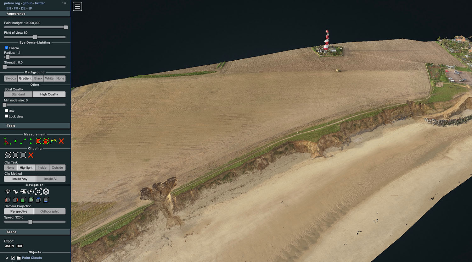
Outcomes
- Four quarterly surveys delivered across 12 months
- Accurate 3D point clouds and terrain data for erosion analysis
- Survey time reduced by 80% through technology and process improvements
- Minimal public disruption and enhanced operational safety
Result: Faster, safer, and more accuratecoastal monitoring to support critical infrastructure planning.
<
Case Study
>
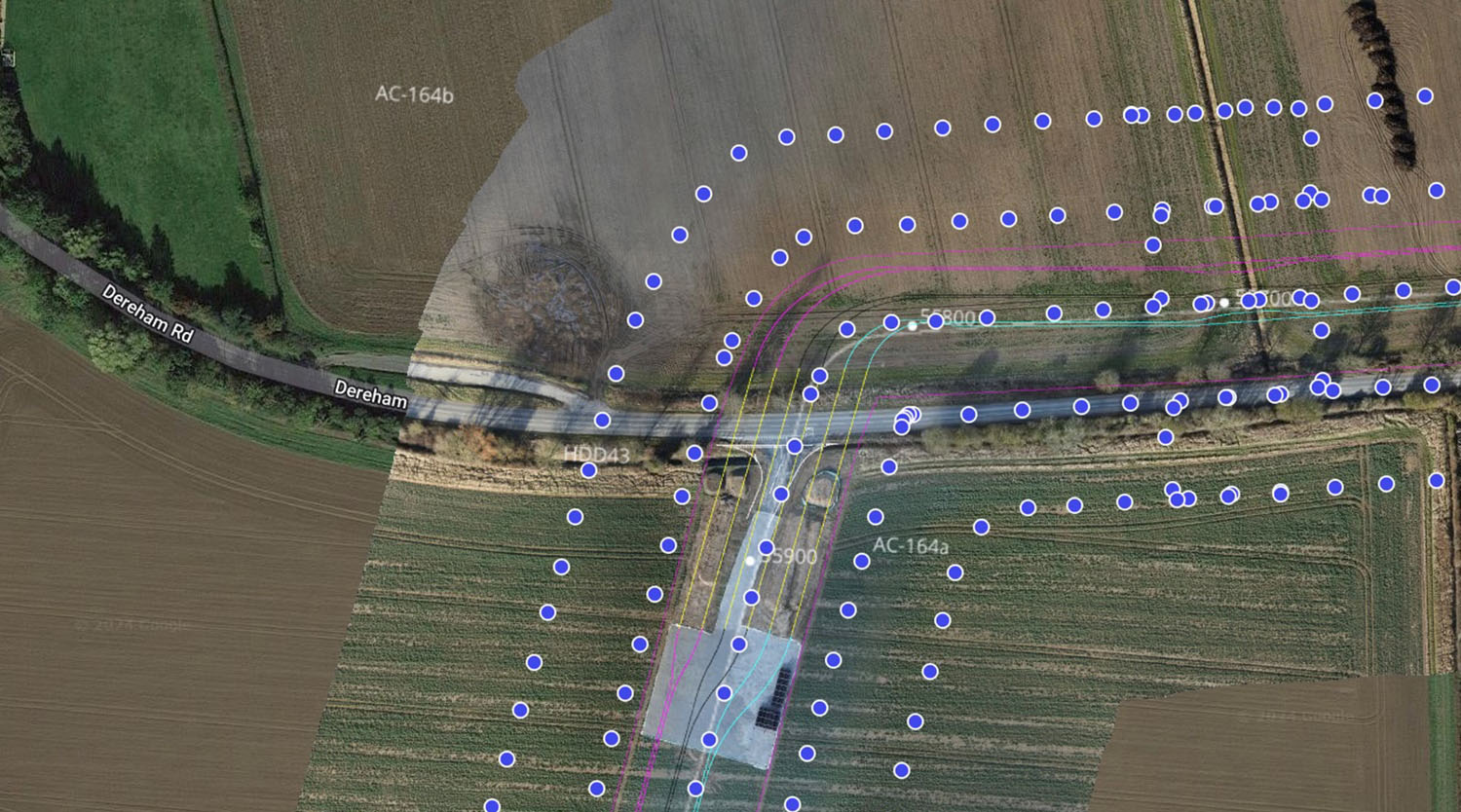
60km Corridor Fly-through and Topographic Survey, J Murphy & Sons
The Problem
Monitoringprogress across a 60 km site is complex and time-consuming. Ground-levelsurveys face access challenges and can’t provide the full picture. JMS neededan efficient, non-intrusive solution to track fast-moving work fronts andidentify potential issues early.
The Solution
Buildingon our early works LiDAR and fly-through surveys, StirlingX delivers monthlyaerial mapping using DJI M300 RTK drones with P1 full-frame cameras for 1.5 cmGSD imagery. Our CAA-approved Extended Visual Line of Sight (EVLOS) permissionsand optimised flight planning allow efficient coverage with minimal disruption.
Imageryis processed in DroneDeploy tocreate interactive 2D maps, layered with project drawings, and 3D models forvolumetric analysis and progress tracking. Teams can annotate points ofinterest, share updates, and plan efficiently—improving collaboration andlandowner engagement.
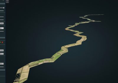
Outcomes
- 20 km section mapped in under a day(with expansion planned to full 60 km)
- High-resolution geolocated imagery and 3D models for real-time project insight
- Faster progress monitoring, reduced site access challenges, and improved decision-making
Result: Accurate, collaborative, and up-to-date visual intelligence that keeps large-scale construction projects moving smoothly.
<
Case Study
>
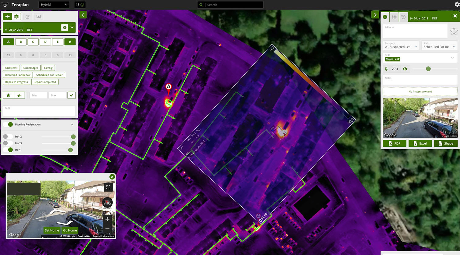
Nottingham District Heating Network (DHN) Citywide Thermographic Survey, Mapping & Reporting
The Problem
DHN leaks are difficult to detect—especially small, hidden faults under private or inaccessible land. Losses cost Enviroenergy an estimated £150,000 in 2018, with undetected leaks wasting up to 12 m³ of water per day. Traditional ground-based thermal surveys couldn’t provide full coverage quickly or safely.
The Solution
StirlingX combined advanced mission planning, thermal drone technology, and specialist analysis to deliver accurate, actionable data. Using automated flight routes(linear + grid patterns) and multiple Take-Off and Landing Sites across Nottingham, we captured 290 ha of thermal data over two nights. The imagery wasprocessed into a thermal orthomap with geo-located anomaly reporting, accessible via Drone Systems’ Teraplan platform. This allowed Enviroenergy to identify and categorise leaks to within 20–30 cm accuracy—prioritising repairs and improving network efficiency.

Outcomes
- Full citywide thermal survey completed in 48 hours
- Geo-located anomaly detection for faster, targeted maintenance
- Significant potential cost savings and reduced heat loss across the network
Result: Safer, smarter fault detection and improved system performance without disruptive or costly ground inspections
<
Case Study
>
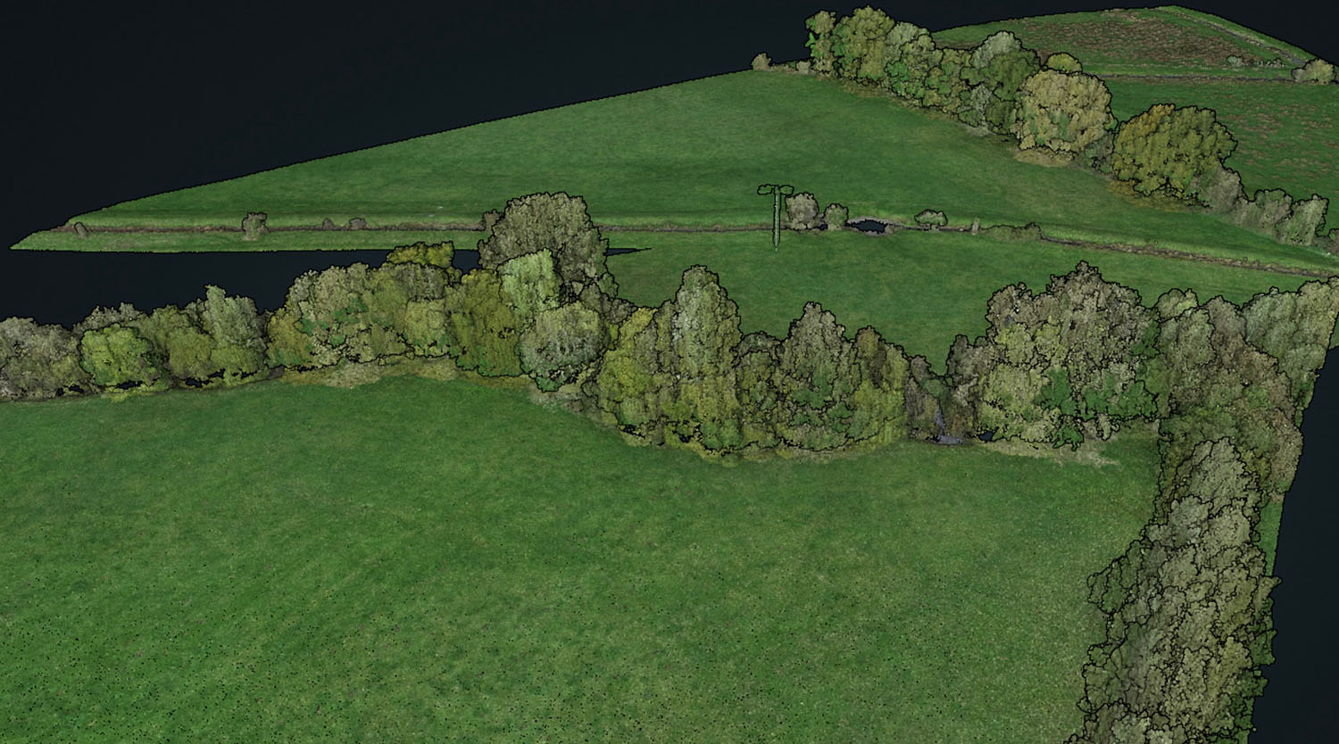
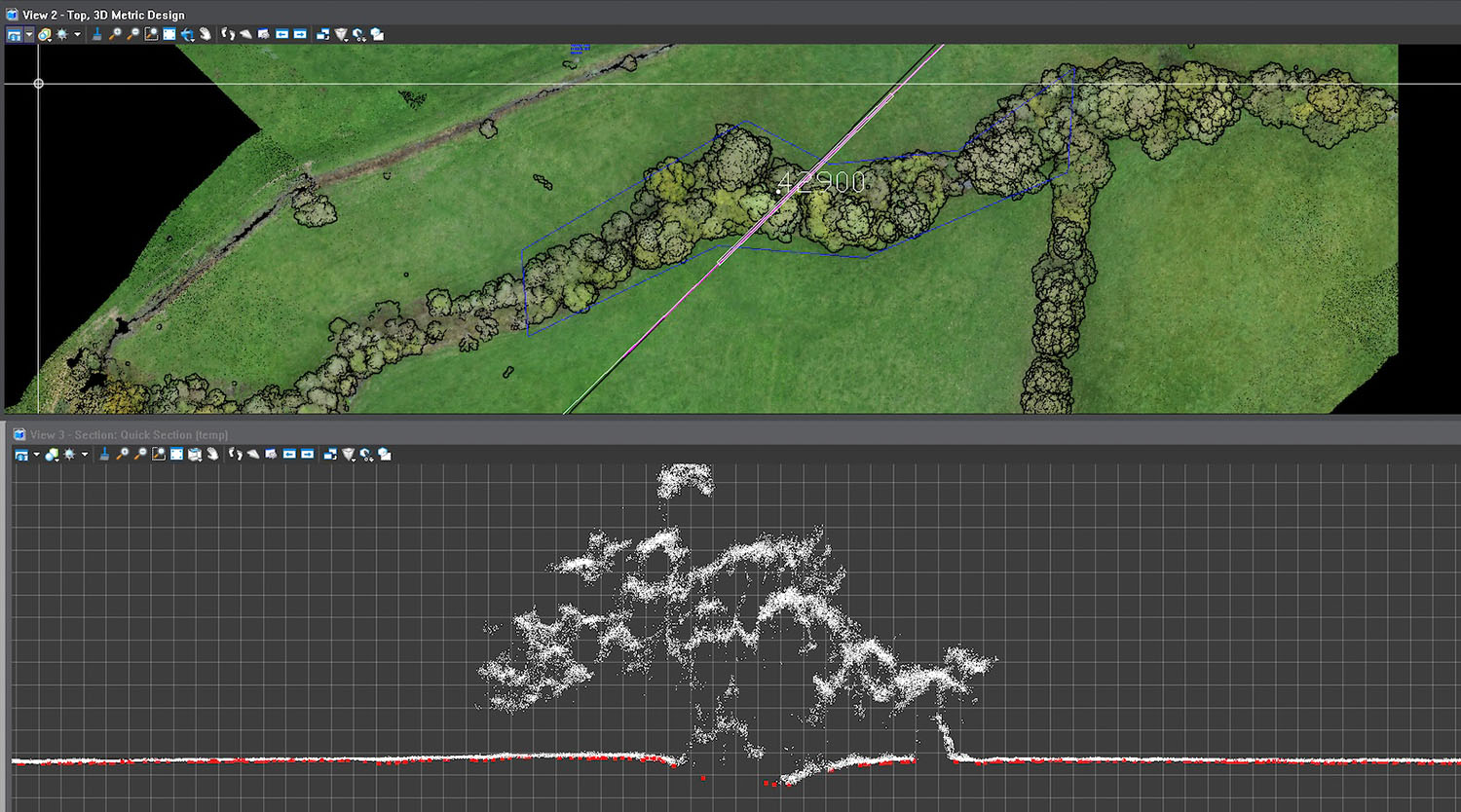
60 km Cable Corridor LiDAR Topographic Survey, J Murphy & Sons
The Problem
Previous photogrammetry surveys offered surface-level detail but couldn’t penetrate vegetation or crop cover, producing only a Digital Surface Model (DSM). J Murphy & Sons needed a precise Digital Terrain Model (DTM) to inform access, drainage, and pre-construction planning across the entire 60 km corridor.
The Solution
StirlingX deployed DJI M300 RTK drones with L1 LiDAR sensors to capture high-density data, supported by surveyed Ground Control Points for ±100 mm vertical accuracy. Our CAA-approved Extended Visual Line of Sight (EVLOS) permissions enabled efficient long-distance flights, while strategic Take-Off and Landing Sites ensured safe operations with minimal disruption. Data was processed into tiled deliverables for easy handling and staged release, providing 2D orthomosaics andLiDAR point clouds with 50 PPM density. We worked closely with JMS and landowners to maintain full compliance and communication throughout.
Outcomes
- 60 km corridor surveyed in under 6 days
- High-accuracy LiDAR DTM and orthomosaic mapping delivered
- Enabled informed planning foraccess, drainage, and mobilisation works
Result: Fast, accurate terrainintelligence supporting one of the UK’s largest offshore wind infrastructureprojects.

<
Case Study
>
Digital Twins of 3 Large Food Processing Plants, Hamson Barron Smith
The Problem
The plants had expansive, fragile roofs with no safe access. Scaffolding or MEWPs were impractical and costly. Thousands of isolated images would offer little value—our client needed accurate, navigable, and contextualised data for desktop inspections.
The Solution
UsingDJI M300 drones with P1 sensors, we achieved full coverage from multiple anglesfor all roof areas, creating a perfect dataset for 3D modelling. Our enhancedCAA permissions allowed flights as close as 10m to uninvolved people andseamless control handovers between pilots—minimising disruption.
We processed the imagery into Twinsity’s Twinspect platform, giving surveyors intuitive 3Ddigital twins with linked high-resolution images. Clicking any point in the model reveals precise source images, maintaining situational awareness.
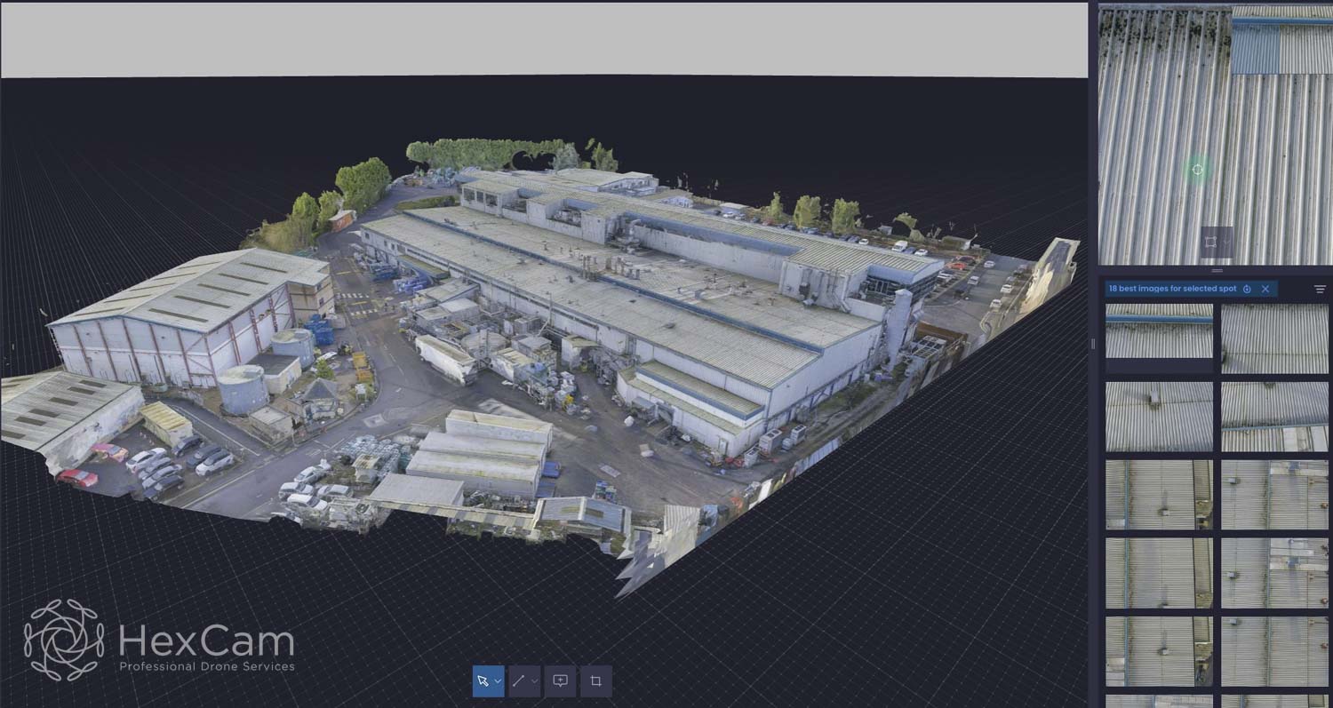
Outcomes
Hamson Barron Smith now conducts comprehensive rooftop surveys remotely, eliminating working-at-height risks. Defects can be annotated directly in the 3D model, streamlining reporting and enabling precise planning for future access or remedial works.


Ready to see what’s possible?
Experience secure autonomy in action. Partner with StirlingX and transform the way you monitor, manage and protect your assets.