< Construction Progress Tracking >
Clear, objective visibility of progress across complex construction sites and linear corridors.
Track project performance, validate progress, and keep every stakeholder aligned with precise, high-frequency construction intelligence.

< OVERVIEW >
Construction Progress Tracking.
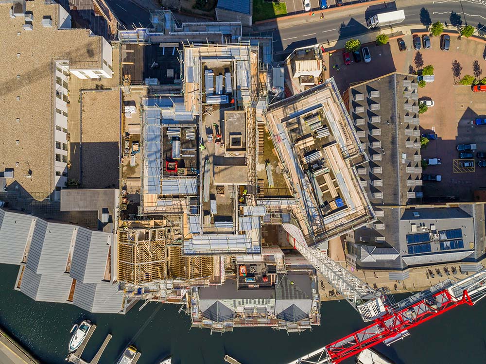
Construction demands accuracy, visibility and tight coordination. StirlingX delivers drone-based construction progress monitoring across sites of any scale, capturing 3D models, orthomosaics and volumetric data on automated flight schedules that fit your programme cadence.
Our aerial surveys give project teams a consistent, objective picture of site progress, so deviations from design, programme slippage and volume discrepancies are visible when they're still fixable rather than after costs have escalated. Clients receive processed data directly into their reporting workflows, with stakeholder-ready outputs available within hours of each flight.

< Key Applications >
What we do.

Progress tracking and performance monitoring. Regular drone surveys of the full site footprint, flown on a fixed cadence to give project managers a consistent aerial record of construction progress.

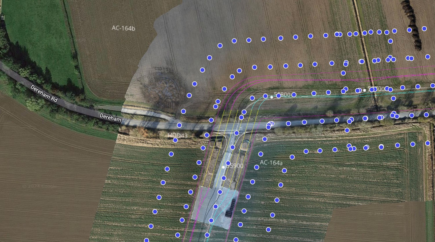
As-built vs. design comparison. Automated overlay of captured site conditions against design models and drawings, identifying deviations in position, elevation and dimension before they become costly rework.

Volumetric stockpile assessment. Accurate drone-based volume calculations for earthworks, aggregate stockpiles, cut-and-fill operations and spoil management.

Digital twin creation. Photorealistic 3D models and point cloud datasets built from each drone survey, forming a running visual record of the site as it develops.

Weekly and monthly update packages. Structured progress packs delivered after each survey, covering orthomosaic imagery, 3D model outputs, volumetric changes, deviation flags and annotated photographs.

Stakeholder dashboards and reporting. Cloud-hosted dashboards giving clients, contractors and project owners on-demand access to the latest site data, historical comparisons and progress metrics.

Time-lapse and video documentation. Aerial time-lapse sequences compiled from repeat survey imagery, showing construction progress across the full programme duration.
< Process >
How we work.
Briefing
We start by understanding your programme structure, reporting cadence and the specific outputs your team and stakeholders need. That means agreeing on survey frequency, data formats, accuracy requirements, and the design files or BIM models we'll be comparing against, as well as who receives what at each reporting interval.
Capture
Drone surveys are flown on pre-planned automated paths covering the full site footprint, with missions repeating on the same tracks each time so datasets are directly comparable across the programme. Payload selection depends on your data requirements: RGB cameras for visual progress and orthomosaics, LiDAR for volumetric accuracy and terrain modelling, or both where the programme demands it.
Process
Captured data uploads into our secure cloud environment and processes automatically into georeferenced 3D models, orthomosaics and digital surface models, all referenced to the site coordinate system. Volumetric calculations, as-built comparisons and deviation analysis run against the processed datasets before any outputs are released.
Analyse
Processed survey data is overlaid against design models, drawings or the previous capture to generate progress calculations and deviation reports. Earthwork volumes are extracted from the terrain model and compared against programme forecasts. Areas of significant deviation, whether in position, elevation or surface condition, are flagged and annotated for review.
Report
Project teams receive a structured progress pack after each survey, containing orthomosaic imagery, 3D model access, volumetric summaries, deviation annotations and a written progress note. Stakeholder dashboards update automatically so clients and project owners can view current site conditions without requesting a report.
< TECHNOLOGY STACK >
The foundation that powers your operations.
StirlingX runs on infrastructure designed for reliability and speed. Our platform integrates seamlessly with what you already have, no rip and replace required.

RGB cameras for high-resolution site capture

Photogrammetric 3D modelling

LiDAR for complex or obscured terrains
MAYNE dashboards with progress layers
Time-lapse & video packages for site documentation


< Benefits >
How we're different.
Transparent site performance
For internal and client reporting.
Reduced rework and risk
Through early issue identification.
Strong contractor accountability
With objective data.
Clear audit trails
For compliance and claims.
Better planning
With accurate volume and material insights.
“We’ve worked with StirlingX since 2019 and were delighted to award them this framework. Their ability to combine cutting-edge permissions, efficiency, and data integrity makes them an invaluable partner.”
“The ability to pinpoint exact defect locations was invaluable given the size of the roofs. Data management is much easier.”
< Case Studies >
What we've accomplished. Real solutions from real projects.

Find answers about how StirlingX works and what to expect.
Need more information? Reach out to discuss your specific situation.
How long does implementation take?
Will this disrupt our operations?
What about our existing systems?
How do you measure success?
What support continues after launch?
Ready to move forward?
Get in touch with our team to discuss your specific needs today.