< District heating >
Catch the fault,
before it becomes a leak.
StirlingX flies thermal sensors over live district heating networks, beyond visual line of sight and directly above occupied streets, to catch failing joints and early-stage faults before they turn into serious leaks. Without trial holes, without road closures, and with findings your engineers can act on in days.
< The problem >
A losses figure is not a location.
District heating networks run for miles beneath live streets, car parks and occupied buildings. Most of the asset is invisible from ground level, so when losses show up on a meter the traditional next step is survey crews, trial holes and traffic management, working section by section until something turns up.
Ofgem's regulatory framework raises the bar again. Operators are now expected to evidence the condition of a network, rather than react to a losses figure once it has already reached a bill.
Ground survey is slow, it disrupts the people living and working above your network, and it rarely narrows the search before a crew is already on site.

< Why the permission matters >
Most drone surveys cannot legally fly your network.
A thermal survey is only as useful as the airspace it is allowed to cover. Standard commercial drone operations fly within visual line of sight, at short range, over ground that has been cleared of people. Over a live urban heat network that means closing streets and walking a crew along the route, which is the disruption you were trying to avoid.
Our permissions remove that constraint, which is what turns a thermal survey from a site-by-site exercise into something that can cover a whole network in a night.
Standard Drone Survey
StirlingX / BVLOS-VM
Visual line of sight only, pilot repositions every few hundred metres
Automated routes across the whole network under one flight plan
Streets and public areas cleared before flying
Flies directly over occupied streets and buildings, no clearance needed
Site by site, spread across days or weeks
Citywide coverage in as little as two nights
Raw imagery handed over for someone else to interpret
Categorised anomalies, geo-located to within one metre.
< How It Works >
Plan. Fly. Process. Report.
Four steps between a scope call and a location your crew can be sent to.
Plan
>
Fly
>
Process
>
Report
Flight planning
Linear and grid routes mapped across your network and timed overnight, when the thermal contrast between a leak and the ground above it is at its clearest. Airspace and site permissions are handled by us.
Thermal capture
Automated BVLOS-VM flights carry thermal sensor payloads across buried and above ground infrastructure, covering hundreds of hectares in a single night with multiple take-off and landing sites.
Processing data
Imagery is built into a geo-located thermal orthomap accurate to 20 to 30cm. Every anomaly is analysed and categorised by severity by our team, rather than passed on as a folder of raw files.
Findings, not files
Categorised, prioritised findings reach your engineers through Teraplan, built with our partner Drone Systems, so a crew can be sent to a location rather than a search area.
< Proof >
Two networks. Two nights. Real leaks found.
Both surveys below were flown under the permissions above, with no road closures on either.
< Enviroenergy >
Nottingham District Heating Network
Citywide thermographic survey, mapping and reporting.
290
Hectares surveyed
48
Hours, across two nights
£150k
Estimated annual losses
0
Road closures required
Undetected leaks were costing an estimated £150,000 a year, with up to 12 cubic metres of water a day disappearing underground before anyone knew where. StirlingX surveyed the full network across two nights of automated thermal flights, then delivered a categorised, geo-located anomaly map ready for engineers to act on rather than interpret.
< Bring Energy >
Stratford District Heat Network
Thermal monitoring and water loss investigation.
2m
Litres held in network
20-30t
Lost per day, Stratford section
3
Category B leaks identified
2
Early faults caught pre-failure
Our survey identified three Category B leaks, including one potentially linked to underground rail infrastructure, and flagged two early-stage faults before they became confirmed failures. It also gave Bring Energy independent confirmation that their own plan to split and isolate sections of the network was the right call.

< The platform >
We fly it. Teraplan turns it into something you can use.
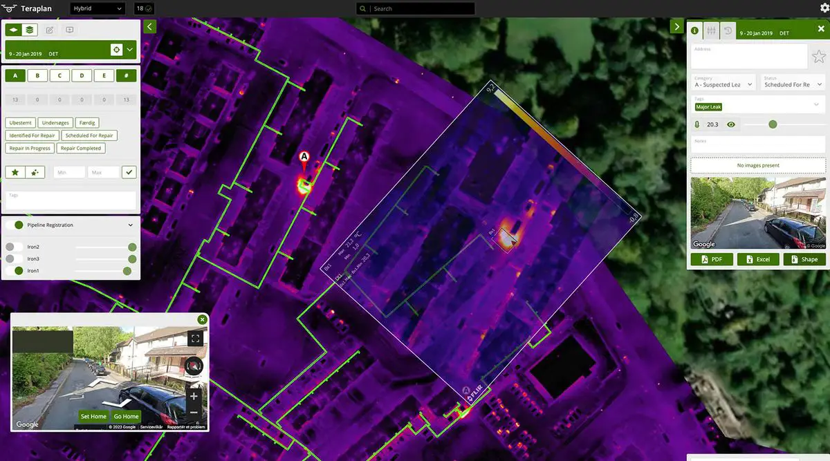
StirlingX handles data capture: the BVLOS-VM flights, the automated routes, the thermal sensors passing over your network overnight. What happens to that data next runs through Teraplan, built by our partner Drone Systems, who have spent years turning raw thermal captures into maps district heating operators can actually act on.
Drone Systems build radiometric orthomaps by combining thousands of individual thermal images into one map of an entire network, then deliver it through Teraplan as an interactive, dynamic tool rather than a PDF that is out of date the day it is printed. You can compare a survey against your own network records, run it alongside previous years' inspections, and see how a section is developing rather than working from a single static snapshot.

x

6,500km+
Network pipelines mapped and analysed
400+
Leaks detected
350+
Emerging leaks caught early
800+
Components flagged for heat loss
Five things operators ask first.
Need more information? Reach out to discuss your specific situation.

Do you need road closures or site access?
What do we actually receive at the end?
How long does a survey take?
Do you dig, or confirm the leak physically?
Does this support our Ofgem reporting?
Find it before it fails.
Tell us the size of your network and we will scope a survey, with a flight plan, a timeline and a cost, before you commit to anything.