
Today StirlingX has secured a UK SORA-based Operational Authorisation for routine BVLOS operations in the Norfolk corridor. Combined with our earlier CAA approval for dedicated Sandbox trial airspace, which went live last month, this completes the regulatory foundation we've been working towards and clears us to commence operations.
This is routine Beyond Visual Line of Sight. No Visual Observers positioned along the route, no visual mitigation of any kind. A remote pilot at our base at Felthorpe Airfield and our Sparrowhawk fixed-wing drone operating in designated airspace along 60km of the Norfolk Offshore Wind Zone cable corridor.
How we got here
StirlingX has been flying drone surveys along the NOWZ cable corridor for four years, supporting the Vattenfall and J Murphy & Sons construction project connecting 276 offshore turbines to the National Grid at Necton.
We didn't start with BVLOS. Like every operator, we began with standard VLOS approvals under PDRA01, with a remote pilot maintaining visual contact with the drone at all times. From there we progressed to BVLOS with Visual Mitigation, deploying trained Visual Observers along the route in continuous radio contact with the pilot, extending our effective range while meeting CAA requirements under a bespoke Operating Safety Case.
The BVLOS VM approach delivers results, but it carries real operational costs. Putting crew and vehicles on the ground across a long rural corridor introduces its own risks, and every repositioning of observers means additional take-offs and landings. The number of flight days required to complete a monthly survey is far higher than it needs to be, and the ground footprint is larger than it should be for what is fundamentally an aerial survey task.
The goal has always been to reach a point where a single pilot, remotely based at an airfield, can fly a full corridor survey in a fraction of the time, which is exactly what these approvals now make possible.
The CAA BVLOS Sandbox
In October 2023, StirlingX was named as one of only five UK companies selected to take part in the CAA's BVLOS Sandbox trials. The programme is designed to make BVLOS drone flights a routine reality in UK airspace, trialling how these operations can be accommodated alongside existing traffic without permanent segregation. Selection required demonstrating a credible operational use case, the technical capability to deliver it safely, and the regulatory maturity to work through a genuine airspace change process.
Our application was built around the NOWZ corridor: along, linear infrastructure project in rural Norfolk, with a defined flightpath, a known air traffic environment, and a clear commercial rationale that aligned closely with what the Sandbox was designed to test.
The Operational Authorisation
The new OA is assessed at UK SORA SAIL 2 and is valid until June 2027, reflecting a safety case built around the UK SORA methodology and accepted by the CAA as robust and scalable. It authorises untethered BVLOS flights within defined operational volumes up to 400ft AGL in both Class D and Class G airspace, approved up to Ground Risk Class 6 with specified mitigations including sheltering and ground observation.
The assessment reflects CAA confidence in our ability to manage both air and ground risk in a relatively complex operational environment. It also places us within the framework the CAA set out in CAP 3038and CAP 3182 on the path to routine BVLOS by 2027, moving us from trial and demonstration activity into repeatable, routine operations in segregated airspace.
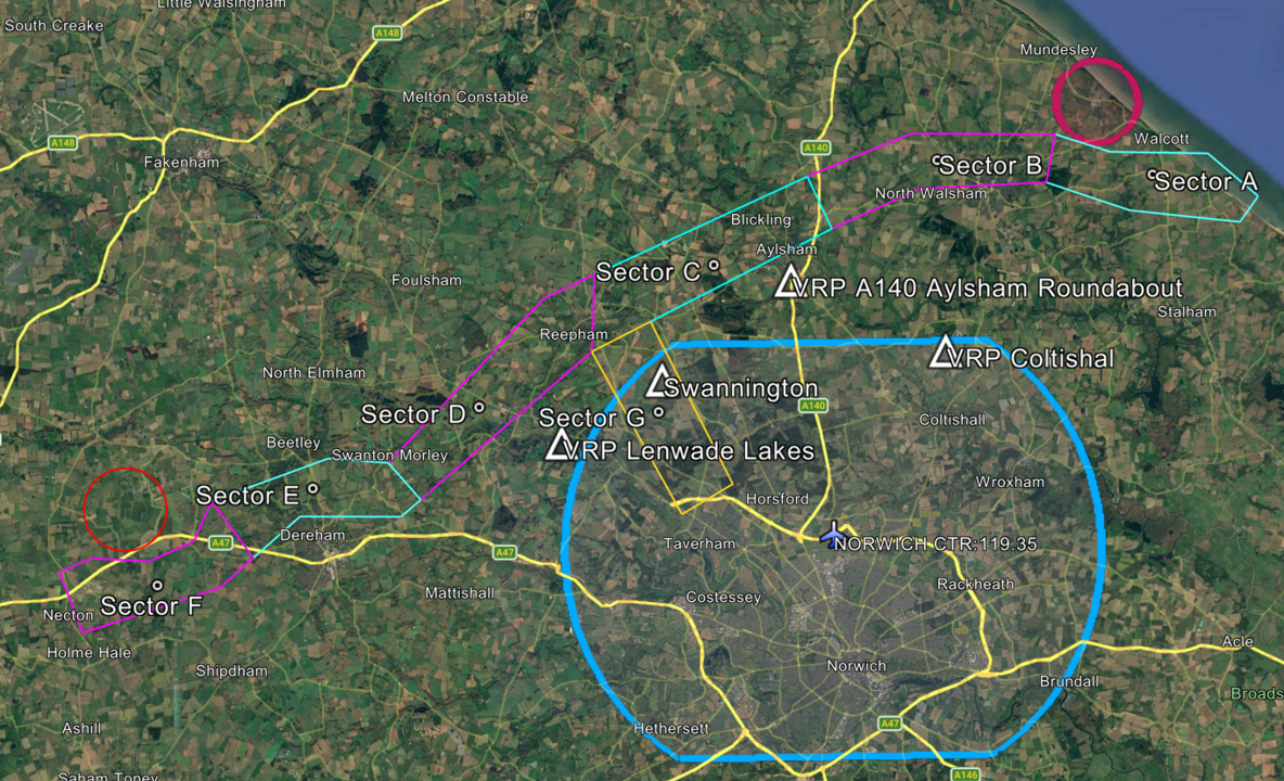
The approved airspace
The Temporary Reserved Area broadly follows the NOWZ cable corridor from its landfall near Happisburgh on the Norfolk coast, west to the substation at Necton. A link corridor extends south from Cawston to Felthorpe Airfield, where our remote pilots will be based. The TDA has a vertical ceiling of 750ft on the Norwich QNH, equivalent to approximately 500ft AGL along the route, with all survey flights operating between 300ft and 400ft AGL.
The TDA is divided into three independently activatable sections: west, centre and east. Each activation is announced by NOTAM, and during activation only transponder-equipped aircraft may operate within the TDA. Norwich ATC is the Air Navigation Service Provider for the trial, managing the TDA and providing a flight information service to our remote pilots, a relationship developed over months of coordination and planning that is central to the safety architecture of the whole operation.
The aircraft
Our Sparrowhawk is a fixed-wing VTOL drone built for exactly this kind of operation. It carries ADS-B transmit and receive, a Mode S transponder, redundant 4G/5G command and control links, high-intensity strobe lighting and around two hours of endurance at a cruise speed of up to 50 knots. It's electronically visible to EC ground stations along the route via PilotAware ATOM stations, and to any other aircraft with an ADS-B receiver, which is a fundamental requirement for operating without visual observers on the ground.
The sensor payload covers the core survey requirements: LiDAR for terrain and asset modelling, photogrammetry for construction progress and environmental monitoring, and video for real-time situational awareness and review.
What comes next
With the Operational Authorisation now in place and the Temporary Danger Area EGD297 established, the next phase is about proving that routine BVLOS corridor operations can be flown safely and repeatably within a managed TDA/TMZ environment. Over the coming months we will focus on flying regular missions along the Norfolk corridor, collecting data on safety performance, system reliability and airspace interactions under the specific conditions set out in our UK SORA‑based OA.
There is no predefined roadmap for this corridor that removes either the TDA or the TMZ, and we are not assuming one. Instead, our emphasis is on demonstrating what can be achieved today: a single remote pilot at Felthorpe, a fixed‑wing BVLOS platform, a defined operational volume and a collaborative surveillance environment where electronically conspicuous traffic is known to Norwich ATC and to our ground systems.
The approvals we now hold give us more than a one‑off trial; they provide a pattern we can reuse where a TDA is the appropriate tool. The combination of a UK SORA SAIL 2safety case, defined flight and contingency volumes with an associated ground risk buffer, and ANSP‑managed services within a TDA/TMZ structure creates a deployable model for other long linear infrastructure projects. As we build operational hours in EGD297, we will share lessons with the CAA, Norwich ATC and other stakeholders to inform future policy on how BVLOS accommodation in TDA airspace can support the wider Future of Flight programme.
Why this matters
Routine BVLOS over long linear infrastructure isn't a niche capability. Power lines, pipelines, rail corridors, cable routes: these are the assets that need the most frequent inspection and monitoring, and they're exactly the ones that VLOS operations struggle to cover efficiently .The UK's Future of Flight framework explicitly targets infrastructure inspection as a priority BVLOS use case by 2027, and holding a live OA in a CAA Sandbox corridor positions StirlingX as a credible delivery partner for those programmes.
The model we're building in Norfolk, a remote pilot, a fixed-wing drone, designated trial airspace and integrated ATC coordination, is the template for how this kind of work gets done at scale. We'll be sharing progress as operations develop.
Full details of the trial, the proposed TDA and the consultation process are on our website: https://www.stirlingx.io/legals/bvlos-sandbox-trial
