We want to keep aviation stakeholders updated about our ongoing CAA BVLOS Trial, including the consultation that is currently taking place around the proposed introduction of a Temporary Reserved Area (TRA) in Norfolk’s airspace. Below you will find full details of the proposed TRA, the forecast timeline for the ‘BVLOS Sandbox’ trial and the real-life construction project being used as a test bed for this new class of designated airspace.
A ‘regulatory sandbox’ allows innovators to trial new products, services and business models in a real-world environment without some of the usual rules applying. To avoid any confusion, we should stress that the ‘TRA’ detailed in this consultation is NOT the same as a “Restricted Area (Temporary)” (RA(T)) or “Temporary Danger Area” (TDA). Once you’ve reviewed the details below in full, we would welcome your comments and feedback using the form at the bottom of this page.
Project Background
StirlingX is a professional drone services provider with over 13 years of commercial experience. We provide drone-based aerial survey, mapping, asset inspection, construction monitoring, thermal imaging and creative imaging services across a range of industries including major infrastructure construction projects associated with the connection of large offshore wind farms onto the National Grid. StirlingX has been providing aerial survey and mapping services to both Vattenfall and J Murphy & Sons for the Norfolk Offshore Wind Zone (NOWZ) project (Norfolk Boreas and Norfolk Vanguard East and West) for the past 4 years. We’re currently carrying out monthly ‘construction progress’ surveys along the centre and eastern sections of the cable corridor between the River Wensum at Elsing and Happisburgh.
The Norfolk Offshore Wind Zone (NOWZ) is a renewable energy project involving the installation of 276 wind turbines in the North Sea off the coast of Norfolk. The cables from the turbines reach the Norfolk Coast at Happisburgh and will pass through Norfolk to Necton where the power will be fed into the National Grid. The cable corridor across Norfolk is under construction. StirlingX has carried out monthly construction and environmental monitoring surveys throughout the project.
Link to further information on the NOWZ: https://norfolkzone.rwe.com/about-norfolk
Follow this link to find an Interactive map of the NOWZ plan: https://norfolkzone.rwe.com/about-norfolk/interactive-map
We currently fly a DJI M350 drone using ‘Beyond Visual Line Of Sight with Visual Mitigation’ (BVLOS VM) with a crew comprising 2 Remote Pilots (RPs) and a Visual Observer (VO). We operate under a CAA Operational Authorisation (UAS117) based on our very latest Operating Safety Case (OSC). All drone survey and mapping flights within the new TRA will be LOW LEVEL – between 300ft and 400ft Above Ground Level (AGL). We currently identify the presence of other air users audibly and visually (by the RPs and VO) and through the ADS-B ‘Receive Only’ functionality built into each of the RP’s controllers as well as monitoring a PilotAware feed that collates a number of different methods of electonic conspicuity. However, even with our strobes and LEDs activated, it’s hard for other air users to see us. Our goal is to be able to safely carry out more energy-efficient fixed-wing BVLOS drone surveys and mapping flights along the NOWZ construction corridor in fully integrated airspace from our airfield base in Felthorpe. The CAA’s ‘BVLOS Sandbox’ trial is a key part of our journey towards achieving that goal. The fixed-wing we propose to use on the cable corridor has an ADS-B and mode S transponder and is fully “visible” to Norwich ATC and anybody with an ADS-B receiver.
The CAA ‘BVLOS Sandbox’ Trial
We were delighted to learn in October 2023 that StirlingX had been selected as one of only 6 UK companies to take part in the CAA’s ‘BVLOS Sandbox’ trials to “…help make beyond visual line of sight (BVLOS) drone flights an everyday reality”. The CAA’s press release at the time gave broad details of this particular round of BVLOS trials.
We decided to apply for the ‘BVLOS Sandbox’ trial as a way to progress our technical and operational innovation and to work towards our goal of conducting BVLOS drone missions from our airfield base. By removing the need to deploy RPs and VOs along our survey routes, we can dramatically reduce the risks associated with putting people and vehicles on the ground in rural areas. Without the need to repeatedly land and reposition crew, we can also significantly reduce the number of take-off and landings and therefore the time taken to complete our survey flights.
Proposed TRA Airspace
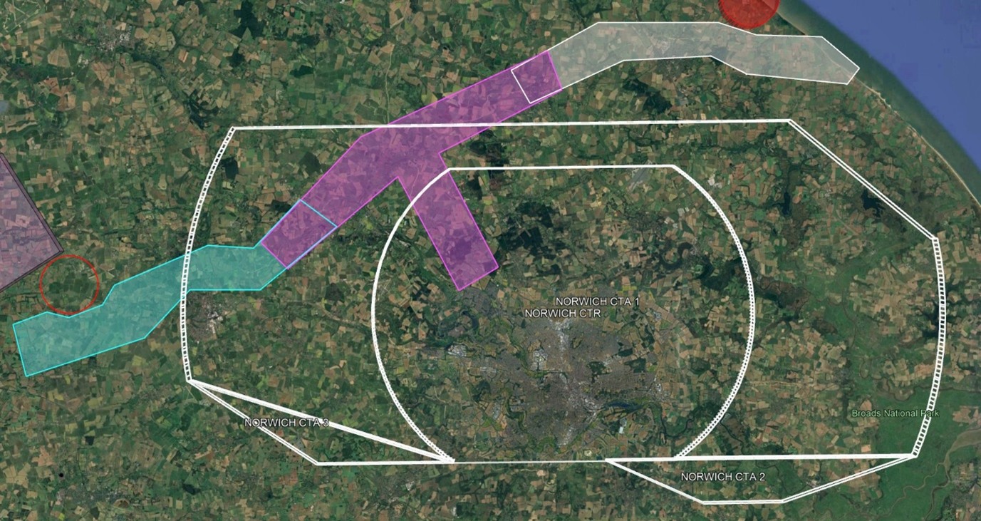
The proposed TRA broadly follows the route of the NOWZ cable corridor from its landfall between Happisburgh and Cart Gap to the substation at Necton. In addition to the NOWZ corridor, the TRA extends south from Cawston towards StirlingX’s base at Felthorpe Airfield. The TRA is best illustrated on a map which can be viewed and explored below:
StirlingX TRA Sandbox – Google My Maps
The vertical extent of the TRA is up to 750ft on the Norwich QNH equating to approximately 500ft AGL along the full route. All drone survey and mapping flights within the TRA will be LOW LEVEL – between 300ft and 400ft Above Ground Level (AGL). The TRA test period is scheduled to run for between 6 and 12 months. Please refer to Phase 4 in “Project Phases & Timeline” below.
Proposed TRA in the context of Norwich controlled airspace (2D):
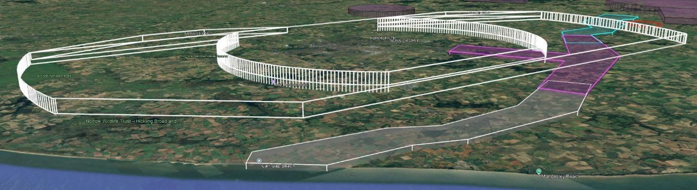
Proposed TRA (ceiling 750 feet AMSL) in the context of Norwich controlled airspace (3D from north-east):
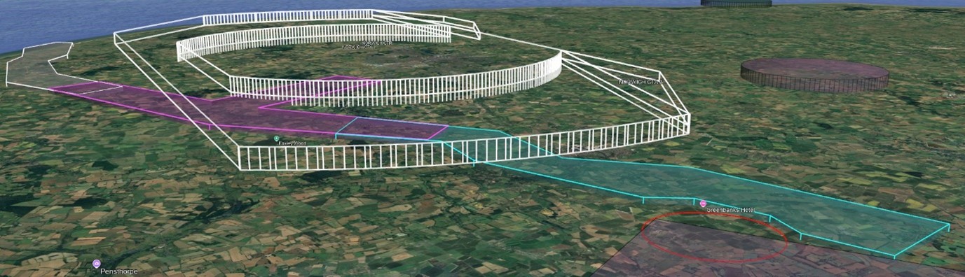
Proposed TRA (ceiling 750 feet AMSL) in the context of Norwich controlled airspace (3D from north-west):
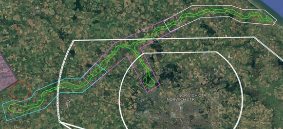
BVLOS flight volume (green):
In advance of the TRA introduction, airspace users will have begun to see more StirlingX Electronic Conspicuity (EC) activity along the cable corridor route as we have now introduced “PilotAware” EC to our DJI M350 flights in Phase 3. Mode A and C (and potentially Mode S) transponders as well as ADS-B (transmit and receive) EC has alsowill start with the arrival of our long-range VTOL drone also in Phase 3. We would welcome feedback from aviation stakeholders on their experience of our EC activity.
We are following the CAP1616 process for the consultation and introduction of this TRA and further details of the process, in the context of BVLOS trials and the CAA’s Airspace Modernisation Strategy (AMS), are available on the CAA website.
Project Phases & Timeline
Phase 1 (Completed) – VLOS Operations
‘Specific Category’ commercial drone operations under a ‘standard’ CAA Operational Authorisation (OA) based on Predefined Risk Assessment PDRA01. Flight restrictions include: Visual Line Of Sight (VLOS) with RP at all times. Maximum flight distance of 500m from RP. Maximum height of 400ft AGL. Note that, with some exceptions, StirlingX no longer uses PDRA01 for large area and long distance survey and mapping operations.
Phase 2 (Completed) – BVLOS With Visual Mitigation (BVLOS VM) No EC
StirlingX is routinely carrying out large area and long distance survey mapping flights across the UK under our latest CAA-approved Operating Safety Case (OSC) that allows us to: Use trained VOs in continuous 2-way radio communication with the RP to maintain VLOS with the drone (BVLOS VM). Extend the VLOS range out to 850m from an RP or VO for our DJI M300 drone. Using a sufficient number of VOs, operate the DJI M300 drone up to 2,500m away from an RP. Operate without Electronic Conspicuity (EC).
Phase 3 (Current Phase) – BVLOS With Visual Mitigation (BVLOS VM) Plus EC
We are now in our ‘risk assessment and quantification phase’ phase. This phase will continue to use our DJI M300 series drones and will introduce a new long-range VTOL drone. The introduction of PilotAware EC to our operations including the addition of an EC device to the DJI M300 and the deployment of multiple ATOM stations along the route, including one at our base in Felthorpe.
The ground-based PilotAware ATOM stations along the route detect electronically conspicuous aircraft including those equipped with:
The ATOM stations transmit this information to the Remote Pilot in real time.
Introduction of the new StirlingX ‘SPARROW HAWK’ fixed wing VTOL drone, equipped with Mode S transponder as well as ADS-B (transmit and receive). NOTAMs will be issued to cover a full week when survey flights are taking place. We will use data gathered from PilotAware to compare against our RP / VO logged observations of crewed aviation in the field. An update to our Operating Safety Case and a revised CAA Operational Authorisation. Increased distances between Airspace Observers (AO) positioned along the route. Sponsoring of additional ATOM stations for airfields in the region.
Phase 4 – BVLOS with Only transponder-equipped Traffic in the TRA
Running for 3 to 6 months from April 2026, this phase will see: Introduction of the proposed TRA (see full details above) activated by NOTAM. While the TRA is activated by NOTAM (expected to be approximately 2 days per month), only transponder-equipped aircraft will be allowed to operate in the TRA. Non-transponder-equipped aircraft will be able to take off from and land at Felthorpe Airfield by following standard arrival and departure procedures, if they are in direct communication with StirlingX’s team at Felthorpe. Risk quantification will be carried out at Norwich Airport comparing Norwich ATC’s Primary and SSR data with other EC systems.
Phase 5 – BVLOS with All Traffic in the TRA
Running for 3 to 6 months from the completion of Phase 4, this phase will be identical to Phase 4 with the significant difference being that the TRA will be open to aircraft equipped with any form of EC.
Phase 6 – Fully Integrated Airspace
This remains the end goal and would see the removal of the Temporary Reserved Area (TRA). All BVLOS flights would be announced by NOTAM.
Feedback Form
We would encourage you to read the above information in full before providing any comment or feedback using the Microsoft form that can be opened using the link below: https://forms.office.com/e/mCnLyybmBp
If you have any questions that you’d like to discuss before submitting your feedback, or if you’re having problems completing the form, please contact Rowley Cory-Wright on 01603 327676 or email engagement@stirlingx.io
Our proposal is also available on the CAA website: https://airspacechange.caa.co.uk/PublicProposalArea?pID=727
FAQs: BVLOS Sandbox Airspace Change
Terminology and definitions
BVLOS – Beyond visual line of sight
CAA – Civil Aviation Authority
CTR – Control zone
DAA – Detect and avoid
EC – Electronic conspicuity
TMZ – Transponder mandatory zone
TRA – Temporary reserved area
UA – Unmanned aircraft (refers to the drone only)
UAS – Unmanned aircraft system (the drone and everything needed to operate it)
SORA – Specific operations risk assessment
General FAQs
Who are StirlingX?
StirlingX (formerly known as HexCam) is a professional drone services provider with over 14 years of experience operating drones across the UK. The company specialises in aerial survey, mapping, asset inspection, construction monitoring, thermal imaging, and creative imaging services. Our work spans multiple industries, including major infrastructure projects—particularly those involving the connection of offshore wind farms to the National Grid.
FAQs for the local aviation community
1. What is the BVLOS Sandbox and why is it being trialled?
The BVLOS Sandbox is a Civil Aviation Authority initiative designed to test the safe integration of unmanned aircraft systems (UAS) operating (BVLOS) in unsegregated UK airspace. The StirlingX phase 4 trials use Temporary Reserved Areas (TRA) and Transponder Mandatory Zones (TMZ) to validate technologies and procedures that could support future routine BVLOS operations.
2. Where will the BVLOS flights take place?
Flights will occur along a 60 km cable corridor in Norfolk, supporting the Norfolk Offshore wind Zone Vanguard and Boreas offshore wind farm construction. The route is almost fully within Class G airspace with TRA/TMZ overlays and also includes a link corridor to Felthorpe Airfield which is partially within the Norwich CTR class D airspace.
3. What is the BVLOS flight profile?
Flights will occur between 200–400 feet AGL, with surveys conducted at 400 feet. Operations are confined to a defined flight volume as shown on our maps.
4. What safety measures are in place to protect other airspace users?
Safety is ensured through the use of EC devices such as ADS-B and Mode S transponders as well as PilotAware. A flight information service from Norwich ATC and activation of airspace via NOTAMs provides further protection. We have additional strategic and tactical mitigations including geofencing, strobe lighting, and real-time telemetry monitoring.
5. How is airspace deconfliction managed?
A Temporary Reserved Area (TRA) and Transponder Mandatory Zone (TMZ) are proposed. The TRA is divided into three sections (west, centre and east) and can be activated independently via NOTAM. Aircraft without transponders must remain above 750 feet AMSL on Norwich QNH whilst over the cable corridor.
6. How is ground risk managed during BVLOS operations?
Ground risk is mitigated by operating in controlled construction zones with restricted public access, avoiding densely populated areas, using onboard FPV cameras and telemetry for real-time ground observation, and applying UK SORA criteria to reduce Ground Risk Class (GRC) to acceptable levels.
7. What role does Norwich ATC play in the trial?
Flights are remotely piloted from Felthorpe Airfield with continuous communication with Norwich ATC. Norwich ATC acts as the Air Navigation Service Provider (ANSP), managing the TRA/TMZ and providing a flight information service to StirlingX Remote Pilots. They support situational awareness and deconfliction, and have been involved in planning and coordination meetings.
8. Will other aircraft be allowed to enter the trial airspace?
Initially, only aircraft with certified transponders or recognised EC devices can enter the TRA/TMZ. As the trial progresses, access may expand to include other EC-equipped aircraft, simulating a more integrated airspace environment.
9. How are local aviation stakeholders being engaged?
StirlingX has conducted outreach with local flying clubs (e.g. Felthorpe Airfield and Norfolk Hang Gliding and Paragliding Club), East Anglia Air Ambulance, military operators (e.g., Wattisham Apache squadrons), and commercial operators at Norwich Airport, as well as giving regular presentations at the East Anglia Airspace Users Working Group (EEAUWG). This ensures mutual notification of flight activity and supports strategic deconfliction.
10. What happens in case of an emergency during BVLOS flights?
Defined emergency procedures include: GNSS loss (transition to multirotor mode and emergency landing), telemetry or C2 loss (loiter or return to emergency landing area), and aircraft incursion (loiter and coordinate with ATC). All incidents are reported and reviewed post-flight.
11. What type of drone is being used in the trial?
The Sparrowhawk FX10NG, a fixed-wing VTOL UAS, is used. It features ADS-B and Mode S transponders, redundant 4G/5G command and control, high-intensity strobe lighting, 2-hour endurance and 50-knot max speed and is designed for safe BVLOS operations in rural environments.
12. How will the trial influence future BVLOS regulations?
Phase 4 aims to validate the airspace policy concept and technologies for BVLOS integration. Insights from this phase will inform Phase 5, which introduces shared airspace between manned and unmanned aircraft, moving towards full integration under UK CAA policy.
FAQs for residents and landowners
1. Why are there drones above the NOWZ cable corridor?
StirlingX is conducting monthly aerial surveys using drones to monitor construction progress and environmental conditions along the Norfolk Offshore Wind Zone cable corridor between Happisburgh and Necton.
2. Will the drones fly over my property?
Flights are planned to avoid built-up areas and will mostly occur over open countryside or restricted construction zones. Take-off and landing points are carefully chosen to minimise land access. StirlingX are approved by the CAA for overflight of uninvolved people, but we avoid this wherever possible.
3. Are the drones noisy or disruptive?
The new aircraft is quieter than previous models that we have used along the corridor since 2021, especially after transition to fixed-wing mode. Surveys will be completed in fewer days each month, reducing overall disruption. We will use a reduced number of take-off points with the new drone, which minimises the requirement for access to private land.
4. How is safety ensured during flights?
All flights are monitored in real time by a trained pilot and coordinated with Norwich Air Traffic Control. The drone is equipped with technology to show its position to other aircraft and we constantly monitor the positions of other aircraft in the area.
5. Will drones affect my privacy?
Flights are focused on monitoring construction and environmental conditions within the cable corridor. The maps created are cropped so they only show the corridor and a small area around.
6. Who can I contact with concerns or questions?
StirlingX has provided these consultation materials and is available to answer questions and to receive comments via our consultation page. You can also view interactive maps and more details of the NOWZ project at https://norfolkzone.rwe.com/about-norfolk.